Codó geodata
Codó (Maranhão) is a populated place; located in Brazil in America/Fortaleza (GMT-3) time zone. With population of 83,288 people, there are 277 cities with bigger population in this country. Compared to other cities in Brazil, 89.6% of cities are located further ↓South; 56.4% of cities are located further ←West and 80.5% of cities have higher elevation than Codó. Note1


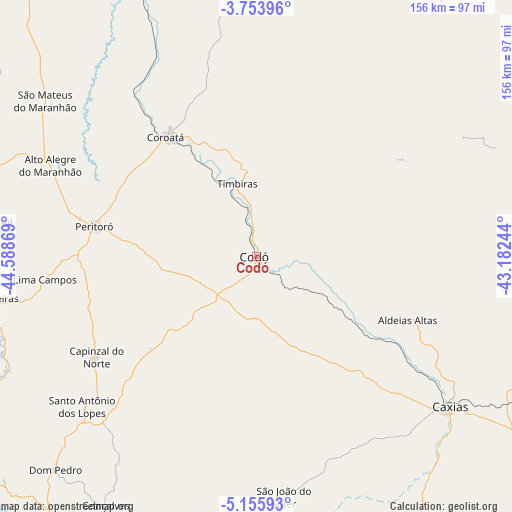
Codó GPS coordinates[2]
4° 27' 19.008" South, 43° 53' 8.016" West
| Map corner | latitude | longitude |
|---|---|---|
| Upper-left | -3.75396°, | -44.58869° |
| Center: | -4.45528°, | -43.88556° |
| Lower-right: | -5.15593°, | -43.18244° |
| Map W x H: | 155.9×155.9 km | = 96.9×96.9mi |
| max Lat: | 2.81972° ⇑10.4% North |
| Codó: | -4.45528° |
| min Lat: | ⇓89.6% South -33.69111° |
| min Long | Codó | max Long |
| -72.89583° | -43.88556° | -32.41083° |
| W 56.4%⇐ | ⇒43.6% E |
Elevation
Elevation of Codó is 44 m = 144 ft, and this is 336.9 m = 1105 ft below average elevation for this country.
| Max E: |
1603 m = 5259 ft | 80.5% |
| Avg. | 380.9 m = 1250 ft | |
| Codó | 44 m = 144 ft | |
Min E: |
0 m = 0 ft | 19.5% |
See also: Codó elevation on elevation.city.
Geographical zone
Codó is located in South Torrid zone (between Equator and Tropic of Capricorn). Distance of Equator is 495.4 km =307.8 mi to North.| Distance of | km | miles | from Codó |
|---|---|---|---|
| Equator | 495.4 | 307.8 | to North |
| Tropic Capricorn | 2110.5 | 1311.4 | to South |
| Antarctic Circle | 6905.8 | 4291.1 | to South |
| South Pole | 9511.7 | 5910.3 | to South |


Nearby cities:
15 places around Codó: (largest is in red/bold)
• Bacabal
102.1 km =63.4 mi,  280°
280°
• Cantanhede
106.4 km =66.1 mi,  329°
329°
• Caxias
73.9 km =45.9 mi,  127°
127°
• Chapadinha
98.4 km =61.1 mi,  36°
36°
• Coelho Neto
99.3 km =61.7 mi,  77°
77°
• Coroatá
44.8 km =27.8 mi,  323°
323°
• Dom Pedro
89.1 km =55.4 mi,  223°
223°
• Esperantinópolis
102 km =63.4 mi,  243°
243°
• Pirapemas
89.3 km =55.5 mi,  335°
335°
• Poção de Pedras
109.4 km =68 mi,  257°
257°
• Santa Rita
65.9 km =40.9 mi,  2°
2°
• São Mateus do Maranhão
79.9 km =49.6 mi,  305°
305°
• Timbiras
23.1 km =14.4 mi, 344°
• União
114.1 km =70.9 mi,  97°
97°
• Vargem Grande
101.5 km =63.1 mi,  358°
358°
Sources, notices
• [Note1] Compared only with cities in Brazil existing in our database
• [Src1] Map data: © OpenStreetMap contributors (CC-BY-SA)
• [Src2] Other city data from geonames.org with taken over terms of usage.
• [Src3] Geographical zone / Annual Mean Temperature by Robert A. Rohde @ Wikipedia
