Chapadinha geodata
Chapadinha (Maranhão) is a populated place; located in Brazil in America/Fortaleza (GMT-3) time zone. With population of 40,804 people, there are 520 cities with bigger population in this country. Compared to other cities in Brazil, 92.4% of cities are located further ↓South; 58.7% of cities are located further ←West and 71.6% of cities have higher elevation than Chapadinha. Note1


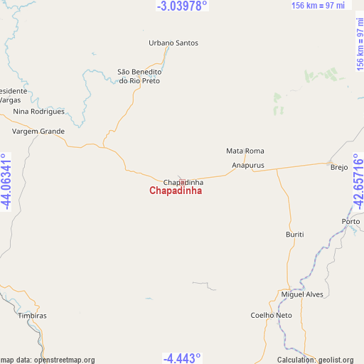
Chapadinha GPS coordinates[2]
3° 44' 30.012" South, 43° 21' 37.008" West
| Map corner | latitude | longitude |
|---|---|---|
| Upper-left | -3.03978°, | -44.06341° |
| Center: | -3.74167°, | -43.36028° |
| Lower-right: | -4.443°, | -42.65716° |
| Map W x H: | 156×156 km | = 96.9×96.9mi |
| max Lat: | 2.81972° ⇑7.6% North |
| Chapadinha: | -3.74167° |
| min Lat: | ⇓92.4% South -33.69111° |
| min Long | Chapadinha | max Long |
| -72.89583° | -43.36028° | -32.41083° |
| W 58.7%⇐ | ⇒41.3% E |
Elevation
Elevation of Chapadinha is 109 m = 358 ft, and this is 271.9 m = 892 ft below average elevation for this country.
| Max E: |
1603 m = 5259 ft | 71.6% |
| Avg. | 380.9 m = 1250 ft | |
| Chapadinha | 109 m = 358 ft | |
Min E: |
0 m = 0 ft | 28.4% |
See also: Chapadinha elevation on elevation.city.
Geographical zone
Chapadinha is located in South Torrid zone (between Equator and Tropic of Capricorn). Distance of Equator is 416 km =258.5 mi to North.| Distance of | km | miles | from Chapadinha |
|---|---|---|---|
| Equator | 416 | 258.5 | to North |
| Tropic Capricorn | 2189.9 | 1360.7 | to South |
| Antarctic Circle | 6985.1 | 4340.3 | to South |
| South Pole | 9591 | 5959.6 | to South |


Nearby cities:
15 places around Chapadinha: (largest is in red/bold)
• Brejo
68 km =42.3 mi,  84°
84°
• Codó
98.4 km =61.1 mi,  216°
216°
• Coelho Neto
69 km =42.9 mi,  146°
146°
• Coroatá
95.1 km =59.1 mi,  242°
242°
• Matias Olímpio
89.3 km =55.5 mi,  88°
88°
• Miguel Alves
69.9 km =43.4 mi,  132°
132°
• Pirapemas
95.8 km =59.5 mi,  270°
270°
• Porto
74.1 km =46 mi,  103°
103°
• Santa Quitéria do Maranhão
93.7 km =58.2 mi,  74°
74°
• Santa Rita
57.1 km =35.5 mi,  256°
256°
• São Benedito do Rio Preto
49.1 km =30.5 mi,  337°
337°
• Timbiras
86 km =53.4 mi,  228°
228°
• União
108.8 km =67.6 mi, 149°
• Urbano Santos
59.6 km =37 mi,  355°
355°
• Vargem Grande
65.5 km =40.7 mi,  289°
289°
Sources, notices
• [Note1] Compared only with cities in Brazil existing in our database
• [Src1] Map data: © OpenStreetMap contributors (CC-BY-SA)
• [Src2] Other city data from geonames.org with taken over terms of usage.
• [Src3] Geographical zone / Annual Mean Temperature by Robert A. Rohde @ Wikipedia
