Pedra geodata
Pedra (Pernambuco) is a populated place; located in Brazil in America/Recife (GMT-3) time zone. With population of 11,196 people, there are 1548 cities with bigger population in this country. Compared to other cities in Brazil, 73.1% of cities are located further ↓South; 89.2% of cities are located further ←West and 74.1% of cities have lower elevation than Pedra. Note1


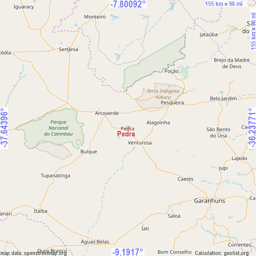
Pedra GPS coordinates[2]
8° 29' 48.984" South, 36° 56' 26.988" West
| Map corner | latitude | longitude |
|---|---|---|
| Upper-left | -7.80092°, | -37.64396° |
| Center: | -8.49694°, | -36.94083° |
| Lower-right: | -9.1917°, | -36.23771° |
| Map W x H: | 154.6×154.6 km | = 96.1×96.1mi |
| max Lat: | 2.81972° ⇑26.9% North |
| Pedra: | -8.49694° |
| min Lat: | ⇓73.1% South -33.69111° |
| min Long | Pedra | max Long |
| -72.89583° | -36.94083° | -32.41083° |
| W 89.2%⇐ | ⇒10.8% E |
Elevation
Elevation of Pedra is 614 m = 2014 ft, and this is 233.1 m = 765 ft above average elevation for this country.
| Max E: |
1603 m = 5259 ft | 25.9% |
| Pedra | 614 m 2014 ft | |
| Avg. | 380.9 m = 1250 ft | |
Min E: |
0 m = 0 ft | 74.1% |
See also: Brazil elevation on elevation.city.
Geographical zone
Pedra is located in South Torrid zone (between Equator and Tropic of Capricorn). Distance of Equator is 944.8 km =587.1 mi to North.| Distance of | km | miles | from Pedra |
|---|---|---|---|
| Equator | 944.8 | 587.1 | to North |
| Tropic Capricorn | 1661.1 | 1032.2 | to South |
| Antarctic Circle | 6456.4 | 4011.8 | to South |
| South Pole | 9062.3 | 5631.1 | to South |


Nearby cities:
15 places around Pedra: (largest is in red/bold)
• Arcoverde
15.2 km =9.4 mi,  304°
304°
• Belo Jardim
59.6 km =37 mi,  72°
72°
• Brejo da Madre de Deus
73.8 km =45.9 mi,  58°
58°
• Buíque
27.5 km =17.1 mi,  239°
239°
• Caetés
46.6 km =29 mi,  131°
131°
• Capoeiras
43.5 km =27 mi, 127°
• Garanhuns
64.5 km =40.1 mi, 131°
• Itaíba
72.9 km =45.3 mi,  226°
226°
• Lajedo
70.7 km =43.9 mi,  105°
105°
• Monteiro
70.4 km =43.7 mi,  343°
343°
• Pesqueira
31 km =19.3 mi, 60°
• Sertânia
59 km =36.7 mi,  322°
322°
• São João
75.9 km =47.2 mi,  123°
123°
• Tupanatinga
52.3 km =32.5 mi, 236°
• Águas Belas
71.2 km =44.2 mi,  196°
196°
Sources, notices
• [Note1] Compared only with cities in Brazil existing in our database
• [Src1] Map data: © OpenStreetMap contributors (CC-BY-SA)
• [Src2] Other city data from geonames.org with taken over terms of usage.
• [Src3] Geographical zone / Annual Mean Temperature by Robert A. Rohde @ Wikipedia
