Caetés geodata
Caetés (Pernambuco) is a populated place; located in Brazil in America/Recife (GMT-3) time zone. With population of 5,386 people, there are 1900 cities with bigger population in this country. Compared to other cities in Brazil, 72% of cities are located further ↓South; 90.4% of cities are located further ←West and 92.1% of cities have lower elevation than Caetés. Note1


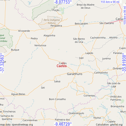
Caetés GPS coordinates[2]
8° 46' 23.016" South, 36° 37' 21" West
| Map corner | latitude | longitude |
|---|---|---|
| Upper-left | -8.07753°, | -37.32563° |
| Center: | -8.77306°, | -36.6225° |
| Lower-right: | -9.46729°, | -35.91938° |
| Map W x H: | 154.5×154.5 km | = 96×96mi |
| max Lat: | 2.81972° ⇑28% North |
| Caetés: | -8.77306° |
| min Lat: | ⇓72% South -33.69111° |
| min Long | Caetés | max Long |
| -72.89583° | -36.6225° | -32.41083° |
| W 90.4%⇐ | ⇒9.6% E |
Elevation
Elevation of Caetés is 843 m = 2766 ft, and this is 462.1 m = 1516 ft above average elevation for this country.
| Max E: |
1603 m = 5259 ft | 7.9% |
| Caetés | 843 m 2766 ft | |
| Avg. | 380.9 m = 1250 ft | |
Min E: |
0 m = 0 ft | 92.1% |
See also: Brazil elevation on elevation.city.
Geographical zone
Caetés is located in South Torrid zone (between Equator and Tropic of Capricorn). Distance of Equator is 975.5 km =606.1 mi to North.| Distance of | km | miles | from Caetés |
|---|---|---|---|
| Equator | 975.5 | 606.1 | to North |
| Tropic Capricorn | 1630.4 | 1013.1 | to South |
| Antarctic Circle | 6425.7 | 3992.7 | to South |
| South Pole | 9031.6 | 5612 | to South |


Nearby cities:
15 places around Caetés: (largest is in red/bold)
• Arcoverde
61.6 km =38.3 mi,  309°
309°
• Belo Jardim
53.3 km =33.1 mi,  24°
24°
• Bom Conselho
44.5 km =27.7 mi,  188°
188°
• Buíque
60.9 km =37.8 mi,  285°
285°
• Cachoeirinha
53.4 km =33.2 mi,  53°
53°
• Canhotinho
48.9 km =30.4 mi,  104°
104°
• Capoeiras
4.3 km =2.7 mi,  353°
353°
• Garanhuns
17.9 km =11.1 mi,  132°
132°
• Lajedo
35.4 km =22 mi,  69°
69°
• Minador do Negrão
64.9 km =40.3 mi,  204°
204°
• Pedra
46.6 km =29 mi, 311°
• Pesqueira
46.9 km =29.1 mi, 350°
• Quebrangulo
62.9 km =39.1 mi,  164°
164°
• Santana do Mundaú
62.1 km =38.6 mi, 134°
• São João
30.3 km =18.8 mi,  112°
112°
Sources, notices
• [Note1] Compared only with cities in Brazil existing in our database
• [Src1] Map data: © OpenStreetMap contributors (CC-BY-SA)
• [Src2] Other city data from geonames.org with taken over terms of usage.
• [Src3] Geographical zone / Annual Mean Temperature by Robert A. Rohde @ Wikipedia
