Garanhuns geodata
Garanhuns (Pernambuco) is a populated place; located in Brazil in America/Recife (GMT-3) time zone. With population of 110,085 people, there are 205 cities with bigger population in this country. Compared to other cities in Brazil, 71.6% of cities are located further ↓South; 90.9% of cities are located further ←West and 97.3% of cities have lower elevation than Garanhuns. Note1


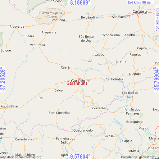
Garanhuns GPS coordinates[2]
8° 52' 55.272" South, 36° 30' 7.776" West
| Map corner | latitude | longitude |
|---|---|---|
| Upper-left | -8.18669°, | -37.20529° |
| Center: | -8.88202°, | -36.50216° |
| Lower-right: | -9.57604°, | -35.79904° |
| Map W x H: | 154.5×154.5 km | = 96×96mi |
| max Lat: | 2.81972° ⇑28.4% North |
| Garanhuns: | -8.88202° |
| min Lat: | ⇓71.6% South -33.69111° |
| min Long | Garanhuns | max Long |
| -72.89583° | -36.50216° | -32.41083° |
| W 90.9%⇐ | ⇒9.1% E |
Elevation
Elevation of Garanhuns is 950 m = 3117 ft, and this is 569.1 m = 1867 ft above average elevation for this country.
| Max E: |
1603 m = 5259 ft | 2.7% |
| Garanhuns | 950 m 3117 ft | |
| Avg. | 380.9 m = 1250 ft | |
Min E: |
0 m = 0 ft | 97.3% |
See also: Garanhuns elevation on elevation.city.
Geographical zone
Garanhuns is located in South Torrid zone (between Equator and Tropic of Capricorn). Distance of Equator is 987.6 km =613.7 mi to North.| Distance of | km | miles | from Garanhuns |
|---|---|---|---|
| Equator | 987.6 | 613.7 | to North |
| Tropic Capricorn | 1618.3 | 1005.6 | to South |
| Antarctic Circle | 6413.6 | 3985.2 | to South |
| South Pole | 9019.5 | 5604.5 | to South |


Nearby cities:
15 places around Garanhuns: (largest is in red/bold)
• Belo Jardim
61.4 km =38.2 mi,  8°
8°
• Bom Conselho
37.5 km =23.3 mi,  211°
211°
• Cachoeirinha
53 km =32.9 mi,  33°
33°
• Caetés
17.9 km =11.1 mi,  312°
312°
• Canhotinho
34.2 km =21.3 mi,  90°
90°
• Capoeiras
21.3 km =13.2 mi,  320°
320°
• Lajedo
31.5 km =19.6 mi,  39°
39°
• Minador do Negrão
61.6 km =38.3 mi,  220°
220°
• Quebrangulo
48.7 km =30.3 mi,  175°
175°
• Quipapá
54.2 km =33.7 mi,  83°
83°
• Santana do Mundaú
44.2 km =27.5 mi,  135°
135°
• São José da Laje
50.8 km =31.6 mi,  106°
106°
• São João
14.9 km =9.3 mi, 87°
• União dos Palmares
60.3 km =37.5 mi,  121°
121°
• Viçosa
61.5 km =38.2 mi,  152°
152°
Sources, notices
• [Note1] Compared only with cities in Brazil existing in our database
• [Src1] Map data: © OpenStreetMap contributors (CC-BY-SA)
• [Src2] Other city data from geonames.org with taken over terms of usage.
• [Src3] Geographical zone / Annual Mean Temperature by Robert A. Rohde @ Wikipedia
