Itaíba geodata
Itaíba (Pernambuco) is a populated place; located in Brazil in America/Recife (GMT-3) time zone. With population of 13,864 people, there are 1302 cities with bigger population in this country. Compared to other cities in Brazil, 71.3% of cities are located further ↓South; 87.1% of cities are located further ←West and 60.7% of cities have lower elevation than Itaíba. Note1


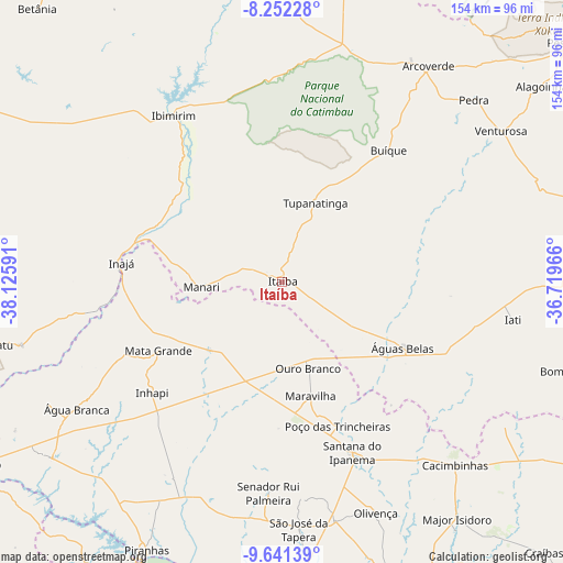
Itaíba GPS coordinates[2]
8° 56' 51" South, 37° 25' 22.008" West
| Map corner | latitude | longitude |
|---|---|---|
| Upper-left | -8.25228°, | -38.12591° |
| Center: | -8.9475°, | -37.42278° |
| Lower-right: | -9.64139°, | -36.71966° |
| Map W x H: | 154.5×154.5 km | = 96×96mi |
| max Lat: | 2.81972° ⇑28.7% North |
| Itaíba: | -8.9475° |
| min Lat: | ⇓71.3% South -33.69111° |
| min Long | Itaíba | max Long |
| -72.89583° | -37.42278° | -32.41083° |
| W 87.1%⇐ | ⇒12.9% E |
Elevation
Elevation of Itaíba is 481 m = 1578 ft, and this is 100.1 m = 328 ft above average elevation for this country.
| Max E: |
1603 m = 5259 ft | 39.3% |
| Itaíba | 481 m 1578 ft | |
| Avg. | 380.9 m = 1250 ft | |
Min E: |
0 m = 0 ft | 60.7% |
See also: Brazil elevation on elevation.city.
Geographical zone
Itaíba is located in South Torrid zone (between Equator and Tropic of Capricorn). Distance of Equator is 994.9 km =618.2 mi to North.| Distance of | km | miles | from Itaíba |
|---|---|---|---|
| Equator | 994.9 | 618.2 | to North |
| Tropic Capricorn | 1611.1 | 1001.1 | to South |
| Antarctic Circle | 6406.3 | 3980.7 | to South |
| South Pole | 9012.2 | 5599.9 | to South |


Nearby cities:
15 places around Itaíba: (largest is in red/bold)
• Arcoverde
71.4 km =44.4 mi,  34°
34°
• Buíque
46.5 km =28.9 mi,  39°
39°
• Cacimbinhas
69.2 km =43 mi,  136°
136°
• Carnaíba
38.4 km =23.9 mi,  315°
315°
• Dois Riachos
60.8 km =37.8 mi, 144°
• Ibimirim
54 km =33.6 mi,  326°
326°
• Inhapi
47 km =29.2 mi,  229°
229°
• Mata Grande
38.9 km =24.2 mi,  240°
240°
• Olivença
68.4 km =42.5 mi,  158°
158°
• Poço das Trincheiras
43.3 km =26.9 mi, 159°
• Santana do Ipanema
51.7 km =32.1 mi, 157°
• São José da Tapera
68.1 km =42.3 mi,  176°
176°
• Tupanatinga
23.4 km =14.5 mi,  22°
22°
• Água Branca
66.3 km =41.2 mi, 238°
• Águas Belas
37.6 km =23.4 mi,  118°
118°
Sources, notices
• [Note1] Compared only with cities in Brazil existing in our database
• [Src1] Map data: © OpenStreetMap contributors (CC-BY-SA)
• [Src2] Other city data from geonames.org with taken over terms of usage.
• [Src3] Geographical zone / Annual Mean Temperature by Robert A. Rohde @ Wikipedia
