Nova Russas geodata
Nova Russas (Ceará) is a populated place; located in Brazil in America/Fortaleza (GMT-3) time zone. With population of 21,986 people, there are 870 cities with bigger population in this country. Compared to other cities in Brazil, 89.3% of cities are located further ↓South; 72.2% of cities are located further ←West and 57.6% of cities have higher elevation than Nova Russas. Note1


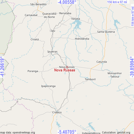
Nova Russas GPS coordinates[2]
4° 42' 24.012" South, 40° 33' 47.016" West
| Map corner | latitude | longitude |
|---|---|---|
| Upper-left | -4.00558°, | -41.26619° |
| Center: | -4.70667°, | -40.56306° |
| Lower-right: | -5.40705°, | -39.85994° |
| Map W x H: | 155.8×155.8 km | = 96.8×96.8mi |
| max Lat: | 2.81972° ⇑10.7% North |
| Nova Russas: | -4.70667° |
| min Lat: | ⇓89.3% South -33.69111° |
| min Long | Nova Russas | max Long |
| -72.89583° | -40.56306° | -32.41083° |
| W 72.2%⇐ | ⇒27.8% E |
Elevation
Elevation of Nova Russas is 239 m = 784 ft, and this is 141.9 m = 466 ft below average elevation for this country.
| Max E: |
1603 m = 5259 ft | 57.6% |
| Avg. | 380.9 m = 1250 ft | |
| Nova Russas | 239 m = 784 ft | |
Min E: |
0 m = 0 ft | 42.4% |
See also: Brazil elevation on elevation.city.
Geographical zone
Nova Russas is located in South Torrid zone (between Equator and Tropic of Capricorn). Distance of Equator is 523.3 km =325.2 mi to North.| Distance of | km | miles | from Nova Russas |
|---|---|---|---|
| Equator | 523.3 | 325.2 | to North |
| Tropic Capricorn | 2082.6 | 1294.1 | to South |
| Antarctic Circle | 6877.8 | 4273.7 | to South |
| South Pole | 9483.7 | 5892.9 | to South |


Nearby cities:
15 places around Nova Russas: (largest is in red/bold)
• Boa Viagem
103.3 km =64.2 mi,  116°
116°
• Cariré
84.7 km =52.6 mi,  6°
6°
• Crateús
54 km =33.6 mi,  193°
193°
• Guaraciaba do Norte
63.4 km =39.4 mi,  341°
341°
• Hidrolândia
36 km =22.4 mi,  22°
22°
• Ibiapina
94.3 km =58.6 mi, 337°
• Independência
81.7 km =50.8 mi,  159°
159°
• Ipu
45.8 km =28.5 mi, 339°
• Novo Oriente
95 km =59 mi, 194°
• Reriutaba
62.9 km =39.1 mi,  358°
358°
• Santa Quitéria
61.4 km =38.2 mi,  47°
47°
• Tamboril
30.3 km =18.8 mi, 117°
• Ubajara
102.7 km =63.8 mi, 337°
• Varjota
57.8 km =35.9 mi, 9°
• Várzea Alegre
74.2 km =46.1 mi, 164°
Sources, notices
• [Note1] Compared only with cities in Brazil existing in our database
• [Src1] Map data: © OpenStreetMap contributors (CC-BY-SA)
• [Src2] Other city data from geonames.org with taken over terms of usage.
• [Src3] Geographical zone / Annual Mean Temperature by Robert A. Rohde @ Wikipedia
