Várzea Alegre geodata
Várzea Alegre (Ceará) is a populated place; located in Brazil in America/Fortaleza (GMT-3) time zone. With population of 21,841 people, there are 873 cities with bigger population in this country. Compared to other cities in Brazil, 87.7% of cities are located further ↓South; 73.2% of cities are located further ←West and 52.2% of cities have higher elevation than Várzea Alegre. Note1


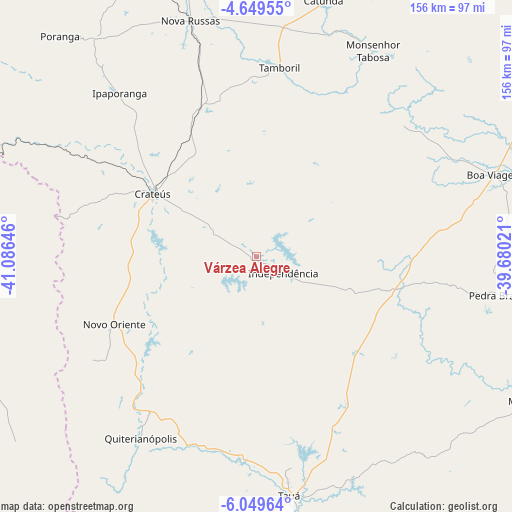
Várzea Alegre GPS coordinates[2]
5° 21' 0" South, 40° 22' 59.988" West
| Map corner | latitude | longitude |
|---|---|---|
| Upper-left | -4.64955°, | -41.08646° |
| Center: | -5.35°, | -40.38333° |
| Lower-right: | -6.04964°, | -39.68021° |
| Map W x H: | 155.7×155.7 km | = 96.7×96.7mi |
| max Lat: | 2.81972° ⇑12.3% North |
| Várzea Alegre: | -5.35° |
| min Lat: | ⇓87.7% South -33.69111° |
| min Long | Várzea Alegre | max Long |
| -72.89583° | -40.38333° | -32.41083° |
| W 73.2%⇐ | ⇒26.8% E |
Elevation
Elevation of Várzea Alegre is 320 m = 1050 ft, and this is 60.9 m = 200 ft below average elevation for this country.
| Max E: |
1603 m = 5259 ft | 52.2% |
| Avg. | 380.9 m = 1250 ft | |
| Várzea Alegre | 320 m = 1050 ft | |
Min E: |
0 m = 0 ft | 47.8% |
See also: Brazil elevation on elevation.city.
Geographical zone
Várzea Alegre is located in South Torrid zone (between Equator and Tropic of Capricorn). Distance of Equator is 594.9 km =369.7 mi to North.| Distance of | km | miles | from Várzea Alegre |
|---|---|---|---|
| Equator | 594.9 | 369.7 | to North |
| Tropic Capricorn | 2011.1 | 1249.6 | to South |
| Antarctic Circle | 6806.3 | 4229.2 | to South |
| South Pole | 9412.2 | 5848.5 | to South |


Nearby cities:
15 places around Várzea Alegre: (largest is in red/bold)
• Boa Viagem
76.2 km =47.3 mi,  71°
71°
• Crateús
37.8 km =23.5 mi,  300°
300°
• Hidrolândia
104.9 km =65.2 mi,  356°
356°
• Independência
9.7 km =6 mi,  121°
121°
• Ipu
119.9 km =74.5 mi,  342°
342°
• Mombaça
94.4 km =58.7 mi, 117°
• Nova Russas
74.2 km =46.1 mi, 344°
• Novo Oriente
47.9 km =29.8 mi,  244°
244°
• Parambu
101.7 km =63.2 mi,  199°
199°
• Pedra Branca
74.6 km =46.4 mi,  98°
98°
• Santa Quitéria
115.9 km =72 mi,  12°
12°
• Senador Pompeu
115.1 km =71.5 mi, 103°
• São João dos Inhamuns
73.1 km =45.4 mi,  171°
171°
• São Miguel do Tapuio
105.4 km =65.5 mi,  260°
260°
• Tamboril
58 km =36 mi, 6°
Sources, notices
• [Note1] Compared only with cities in Brazil existing in our database
• [Src1] Map data: © OpenStreetMap contributors (CC-BY-SA)
• [Src2] Other city data from geonames.org with taken over terms of usage.
• [Src3] Geographical zone / Annual Mean Temperature by Robert A. Rohde @ Wikipedia
