Nhamundá geodata
Nhamundá (Amazonas) is a populated place; located in Brazil in America/Santarem (GMT-3) time zone. With population of 7,772 people, there are 1786 cities with bigger population in this country. Compared to other cities in Brazil, 97.1% of cities are located further ↓South; 96.1% of cities are located further →East and 99.9% of cities have higher elevation than Nhamundá. Note1


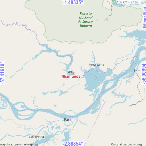
Nhamundá GPS coordinates[2]
2° 11' 9.996" South, 56° 42' 47.016" West
| Map corner | latitude | longitude |
|---|---|---|
| Upper-left | -1.48335°, | -57.41619° |
| Center: | -2.18611°, | -56.71306° |
| Lower-right: | -2.88854°, | -56.00994° |
| Map W x H: | 156.2×156.2 km | = 97.1×97.1mi |
| max Lat: | 2.81972° ⇑2.9% North |
| Nhamundá: | -2.18611° |
| min Lat: | ⇓97.1% South -33.69111° |
| min Long | Nhamundá | max Long |
| -72.89583° | -56.71306° | -32.41083° |
| W 3.9%⇐ | ⇒96.1% E |
Elevation
Elevation of Nhamundá is 1 m = 3 ft, and this is 379.9 m = 1246 ft below average elevation for this country.
| Max E: |
1603 m = 5259 ft | 99.9% |
| Avg. | 380.9 m = 1250 ft | |
| Nhamundá | 1 m = 3 ft | |
Min E: |
0 m = 0 ft | 0.1% |
See also: Brazil elevation on elevation.city.
Geographical zone
Nhamundá is located in South Torrid zone (between Equator and Tropic of Capricorn). Distance of Equator is 243.1 km =151.1 mi to North.| Distance of | km | miles | from Nhamundá |
|---|---|---|---|
| Equator | 243.1 | 151.1 | to North |
| Tropic Capricorn | 2362.8 | 1468.2 | to South |
| Antarctic Circle | 7158.1 | 4447.8 | to South |
| South Pole | 9764 | 6067.1 | to South |


Nearby cities:
15 places around Nhamundá: (largest is in red/bold)
• Alenquer
221.1 km =137.4 mi,  82°
82°
• Barreirinha
78.3 km =48.7 mi,  210°
210°
• Guajará
136.9 km =85.1 mi,  230°
230°
• Itacoatiara
219.7 km =136.5 mi,  241°
241°
• Itaituba
246.1 km =152.9 mi,  160°
160°
• Juruti
69.1 km =42.9 mi,  86°
86°
• Maués
173.8 km =108 mi,  219°
219°
• Monte Alegre
293.2 km =182.2 mi, 85°
• Oriximiná
105.1 km =65.3 mi,  63°
63°
• Parintins
49.2 km =30.6 mi,  182°
182°
• Santarém
224.5 km =139.5 mi,  97°
97°
• Terra Santa
26.7 km =16.6 mi,  70°
70°
• Urucará
122.7 km =76.2 mi,  251°
251°
• Urucurituba
191.7 km =119.1 mi, 236°
• Óbidos
136.1 km =84.6 mi, 77°
Sources, notices
• [Note1] Compared only with cities in Brazil existing in our database
• [Src1] Map data: © OpenStreetMap contributors (CC-BY-SA)
• [Src2] Other city data from geonames.org with taken over terms of usage.
• [Src3] Geographical zone / Annual Mean Temperature by Robert A. Rohde @ Wikipedia
