Juruti geodata
Juruti (Pará) is a populated place; located in Brazil in America/Santarem (GMT-3) time zone. With population of 13,333 people, there are 1343 cities with bigger population in this country. Compared to other cities in Brazil, 97.1% of cities are located further ↓South; 95.4% of cities are located further →East and 86.6% of cities have higher elevation than Juruti. Note1


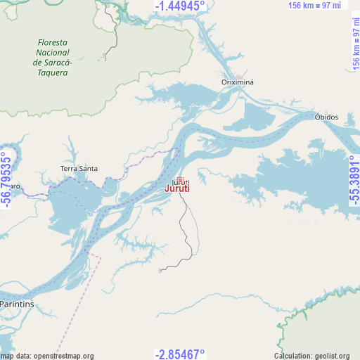
Juruti GPS coordinates[2]
2° 9' 7.992" South, 56° 5' 31.992" West
| Map corner | latitude | longitude |
|---|---|---|
| Upper-left | -1.44945°, | -56.79535° |
| Center: | -2.15222°, | -56.09222° |
| Lower-right: | -2.85467°, | -55.3891° |
| Map W x H: | 156.2×156.3 km | = 97.1×97.1mi |
| max Lat: | 2.81972° ⇑2.9% North |
| Juruti: | -2.15222° |
| min Lat: | ⇓97.1% South -33.69111° |
| min Long | Juruti | max Long |
| -72.89583° | -56.09222° | -32.41083° |
| W 4.6%⇐ | ⇒95.4% E |
Elevation
Elevation of Juruti is 25 m = 82 ft, and this is 355.9 m = 1168 ft below average elevation for this country.
| Max E: |
1603 m = 5259 ft | 86.6% |
| Avg. | 380.9 m = 1250 ft | |
| Juruti | 25 m = 82 ft | |
Min E: |
0 m = 0 ft | 13.4% |
See also: Brazil elevation on elevation.city.
Geographical zone
Juruti is located in South Torrid zone (between Equator and Tropic of Capricorn). Distance of Equator is 239.3 km =148.7 mi to North.| Distance of | km | miles | from Juruti |
|---|---|---|---|
| Equator | 239.3 | 148.7 | to North |
| Tropic Capricorn | 2366.6 | 1470.5 | to South |
| Antarctic Circle | 7161.9 | 4450.2 | to South |
| South Pole | 9767.8 | 6069.4 | to South |


Nearby cities:
15 places around Juruti: (largest is in red/bold)
• Alenquer
152.3 km =94.6 mi,  81°
81°
• Barreirinha
129.9 km =80.7 mi,  236°
236°
• Guajará
196.9 km =122.3 mi, 242°
• Itacoatiara
283.5 km =176.2 mi,  247°
247°
• Itaituba
236.5 km =147 mi,  177°
177°
• Maués
226.7 km =140.9 mi,  232°
232°
• Monte Alegre
224.1 km =139.2 mi,  85°
85°
• Nhamundá
69.1 km =42.9 mi,  266°
266°
• Oriximiná
49.8 km =30.9 mi,  30°
30°
• Parintins
89 km =55.3 mi, 233°
• Santarém
157.1 km =97.6 mi,  101°
101°
• Terra Santa
44.2 km =27.5 mi,  276°
276°
• Urucará
190.1 km =118.1 mi,  257°
257°
• Urucurituba
253.9 km =157.8 mi, 244°
• Óbidos
68.9 km =42.8 mi,  67°
67°
Sources, notices
• [Note1] Compared only with cities in Brazil existing in our database
• [Src1] Map data: © OpenStreetMap contributors (CC-BY-SA)
• [Src2] Other city data from geonames.org with taken over terms of usage.
• [Src3] Geographical zone / Annual Mean Temperature by Robert A. Rohde @ Wikipedia
