Alenquer geodata
Alenquer (Pará) is a populated place; located in Brazil in America/Santarem (GMT-3) time zone. With population of 26,290 people, there are 752 cities with bigger population in this country. Compared to other cities in Brazil, 97.5% of cities are located further ↓South; 93.8% of cities are located further →East and 84.4% of cities have higher elevation than Alenquer. Note1


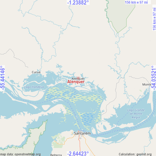
Alenquer GPS coordinates[2]
1° 56' 30.012" South, 54° 44' 17.988" West
| Map corner | latitude | longitude |
|---|---|---|
| Upper-left | -1.23882°, | -55.44146° |
| Center: | -1.94167°, | -54.73833° |
| Lower-right: | -2.64423°, | -54.03521° |
| Map W x H: | 156.3×156.3 km | = 97.1×97.1mi |
| max Lat: | 2.81972° ⇑2.5% North |
| Alenquer: | -1.94167° |
| min Lat: | ⇓97.5% South -33.69111° |
| min Long | Alenquer | max Long |
| -72.89583° | -54.73833° | -32.41083° |
| W 6.2%⇐ | ⇒93.8% E |
Elevation
Elevation of Alenquer is 32 m = 105 ft, and this is 348.9 m = 1145 ft below average elevation for this country.
| Max E: |
1603 m = 5259 ft | 84.4% |
| Avg. | 380.9 m = 1250 ft | |
| Alenquer | 32 m = 105 ft | |
Min E: |
0 m = 0 ft | 15.6% |
See also: Brazil elevation on elevation.city.
Geographical zone
Alenquer is located in South Torrid zone (between Equator and Tropic of Capricorn). Distance of Equator is 215.9 km =134.2 mi to North.| Distance of | km | miles | from Alenquer |
|---|---|---|---|
| Equator | 215.9 | 134.2 | to North |
| Tropic Capricorn | 2390 | 1485.1 | to South |
| Antarctic Circle | 7185.3 | 4464.7 | to South |
| South Pole | 9791.2 | 6084 | to South |


Nearby cities:
15 places around Alenquer: (largest is in red/bold)
• Almeirim
244.2 km =151.7 mi,  79°
79°
• Altamira
314.3 km =195.3 mi,  116°
116°
• Barreirinha
275.8 km =171.4 mi,  249°
249°
• Itaituba
294.1 km =182.7 mi,  208°
208°
• Juruti
152.3 km =94.6 mi,  261°
261°
• Monte Alegre
73.3 km =45.5 mi,  95°
95°
• Nhamundá
221.1 km =137.4 mi, 262°
• Oriximiná
126.9 km =78.9 mi,  278°
278°
• Parintins
234.7 km =145.8 mi, 251°
• Porto de Moz
278.7 km =173.2 mi,  85°
85°
• Prainha
140.7 km =87.4 mi, 83°
• Santarém
55.8 km =34.7 mi,  176°
176°
• Senador José Porfírio
317.6 km =197.3 mi, 103°
• Terra Santa
195.1 km =121.2 mi, 264°
• Óbidos
86.7 km =53.9 mi,  271°
271°
Sources, notices
• [Note1] Compared only with cities in Brazil existing in our database
• [Src1] Map data: © OpenStreetMap contributors (CC-BY-SA)
• [Src2] Other city data from geonames.org with taken over terms of usage.
• [Src3] Geographical zone / Annual Mean Temperature by Robert A. Rohde @ Wikipedia
