Santarém geodata
Santarém (Pará) is a populated place; located in Brazil in America/Santarem (GMT-3) time zone. With population of 189,047 people, there are 124 cities with bigger population in this country. Compared to other cities in Brazil, 96.9% of cities are located further ↓South; 93.7% of cities are located further →East and 79.1% of cities have higher elevation than Santarém. Note1


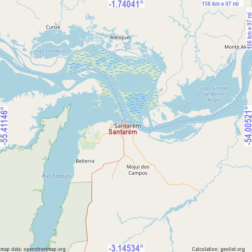
Santarém GPS coordinates[2]
2° 26' 35.016" South, 54° 42' 29.988" West
| Map corner | latitude | longitude |
|---|---|---|
| Upper-left | -1.74041°, | -55.41146° |
| Center: | -2.44306°, | -54.70833° |
| Lower-right: | -3.14534°, | -54.00521° |
| Map W x H: | 156.2×156.2 km | = 97.1×97.1mi |
| max Lat: | 2.81972° ⇑3.1% North |
| Santarém: | -2.44306° |
| min Lat: | ⇓96.9% South -33.69111° |
| min Long | Santarém | max Long |
| -72.89583° | -54.70833° | -32.41083° |
| W 6.3%⇐ | ⇒93.7% E |
Elevation
Elevation of Santarém is 51 m = 167 ft, and this is 329.9 m = 1082 ft below average elevation for this country.
| Max E: |
1603 m = 5259 ft | 79.1% |
| Avg. | 380.9 m = 1250 ft | |
| Santarém | 51 m = 167 ft | |
Min E: |
0 m = 0 ft | 20.9% |
See also: Santarém elevation on elevation.city.
Geographical zone
Santarém is located in South Torrid zone (between Equator and Tropic of Capricorn). Distance of Equator is 271.6 km =168.8 mi to North.| Distance of | km | miles | from Santarém |
|---|---|---|---|
| Equator | 271.6 | 168.8 | to North |
| Tropic Capricorn | 2334.3 | 1450.5 | to South |
| Antarctic Circle | 7129.5 | 4430.1 | to South |
| South Pole | 9735.4 | 6049.3 | to South |


Nearby cities:
15 places around Santarém: (largest is in red/bold)
• Alenquer
55.8 km =34.7 mi,  356°
356°
• Almeirim
257.5 km =160 mi,  66°
66°
• Altamira
290.4 km =180.4 mi,  106°
106°
• Barreirinha
265.2 km =164.8 mi,  261°
261°
• Itaituba
248.1 km =154.2 mi,  214°
214°
• Juruti
157.1 km =97.6 mi,  281°
281°
• Monte Alegre
85.3 km =53 mi,  54°
54°
• Nhamundá
224.5 km =139.5 mi, 277°
• Oriximiná
149.1 km =92.6 mi,  300°
300°
• Parintins
226.2 km =140.6 mi, 264°
• Porto de Moz
285.1 km =177.2 mi, 74°
• Prainha
154.1 km =95.8 mi,  62°
62°
• Senador José Porfírio
306.4 km =190.4 mi,  93°
93°
• Terra Santa
201.2 km =125 mi, 280°
• Óbidos
107.3 km =66.7 mi, 303°
Sources, notices
• [Note1] Compared only with cities in Brazil existing in our database
• [Src1] Map data: © OpenStreetMap contributors (CC-BY-SA)
• [Src2] Other city data from geonames.org with taken over terms of usage.
• [Src3] Geographical zone / Annual Mean Temperature by Robert A. Rohde @ Wikipedia
