Goianinha geodata
Goianinha (Rio Grande do Norte) is a populated place; located in Brazil in America/Fortaleza (GMT-3) time zone. With population of 13,433 people, there are 1337 cities with bigger population in this country. Compared to other cities in Brazil, 84% of cities are located further ↓South; 98% of cities are located further ←West and 90.9% of cities have higher elevation than Goianinha. Note1


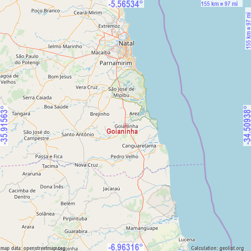
Goianinha GPS coordinates[2]
6° 15' 52.992" South, 35° 12' 45" West
| Map corner | latitude | longitude |
|---|---|---|
| Upper-left | -5.56534°, | -35.91563° |
| Center: | -6.26472°, | -35.2125° |
| Lower-right: | -6.96316°, | -34.50938° |
| Map W x H: | 155.4×155.4 km | = 96.6×96.6mi |
| max Lat: | 2.81972° ⇑16% North |
| Goianinha: | -6.26472° |
| min Lat: | ⇓84% South -33.69111° |
| min Long | Goianinha | max Long |
| -72.89583° | -35.2125° | -32.41083° |
| W 98%⇐ | ⇒2% E |
Elevation
Elevation of Goianinha is 16 m = 52 ft, and this is 364.9 m = 1197 ft below average elevation for this country.
| Max E: |
1603 m = 5259 ft | 90.9% |
| Avg. | 380.9 m = 1250 ft | |
| Goianinha | 16 m = 52 ft | |
Min E: |
0 m = 0 ft | 9.1% |
See also: Brazil elevation on elevation.city.
Geographical zone
Goianinha is located in South Torrid zone (between Equator and Tropic of Capricorn). Distance of Equator is 696.6 km =432.8 mi to North.| Distance of | km | miles | from Goianinha |
|---|---|---|---|
| Equator | 696.6 | 432.8 | to North |
| Tropic Capricorn | 1909.3 | 1186.4 | to South |
| Antarctic Circle | 6704.6 | 4166 | to South |
| South Pole | 9310.5 | 5785.3 | to South |


Nearby cities:
15 places around Goianinha: (largest is in red/bold)
• Arês
9.7 km =6 mi,  36°
36°
• Brejinho
17.9 km =11.1 mi,  297°
297°
• Canguaretama
15.8 km =9.8 mi,  144°
144°
• Jacaraú
39.6 km =24.6 mi,  192°
192°
• Macaíba
47.8 km =29.7 mi,  340°
340°
• Montanhas
25.9 km =16.1 mi,  198°
198°
• Natal
52.2 km =32.4 mi,  0°
0°
• Nova Cruz
34.1 km =21.2 mi,  225°
225°
• Nísia Floresta
19.3 km =12 mi, 1°
• Parnamirim
39.2 km =24.4 mi,  351°
351°
• Pedro Velho
19.4 km =12.1 mi,  182°
182°
• Santo Antônio
29.9 km =18.6 mi,  260°
260°
• São Gonçalo do Amarante
54 km =33.6 mi, 346°
• São José de Mipibu
21.3 km =13.2 mi, 352°
• São José do Campestre
55.7 km =34.6 mi, 264°
Sources, notices
• [Note1] Compared only with cities in Brazil existing in our database
• [Src1] Map data: © OpenStreetMap contributors (CC-BY-SA)
• [Src2] Other city data from geonames.org with taken over terms of usage.
• [Src3] Geographical zone / Annual Mean Temperature by Robert A. Rohde @ Wikipedia
