Milagres geodata
Milagres (Ceará) is a populated place; located in Brazil in America/Fortaleza (GMT-3) time zone. With population of 12,588 people, there are 1412 cities with bigger population in this country. Compared to other cities in Brazil, 78.5% of cities are located further ↓South; 80.8% of cities are located further ←West and 51.1% of cities have higher elevation than Milagres. Note1


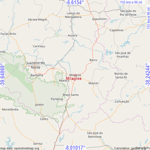
Milagres GPS coordinates[2]
7° 18' 47.988" South, 38° 56' 44.016" West
| Map corner | latitude | longitude |
|---|---|---|
| Upper-left | -6.6154°, | -39.64869° |
| Center: | -7.31333°, | -38.94556° |
| Lower-right: | -8.01017°, | -38.24244° |
| Map W x H: | 155.1×155.1 km | = 96.4×96.4mi |
| max Lat: | 2.81972° ⇑21.5% North |
| Milagres: | -7.31333° |
| min Lat: | ⇓78.5% South -33.69111° |
| min Long | Milagres | max Long |
| -72.89583° | -38.94556° | -32.41083° |
| W 80.8%⇐ | ⇒19.2% E |
Elevation
Elevation of Milagres is 341 m = 1119 ft, and this is 39.9 m = 131 ft below average elevation for this country.
| Max E: |
1603 m = 5259 ft | 51.1% |
| Avg. | 380.9 m = 1250 ft | |
| Milagres | 341 m = 1119 ft | |
Min E: |
0 m = 0 ft | 48.9% |
See also: Brazil elevation on elevation.city.
Geographical zone
Milagres is located in South Torrid zone (between Equator and Tropic of Capricorn). Distance of Equator is 813.2 km =505.3 mi to North.| Distance of | km | miles | from Milagres |
|---|---|---|---|
| Equator | 813.2 | 505.3 | to North |
| Tropic Capricorn | 1792.8 | 1114 | to South |
| Antarctic Circle | 6588 | 4093.6 | to South |
| South Pole | 9193.9 | 5712.8 | to South |


Nearby cities:
15 places around Milagres: (largest is in red/bold)
• Aurora
41.3 km =25.7 mi,  356°
356°
• Barbalha
39.6 km =24.6 mi,  270°
270°
• Barro
66.9 km =41.6 mi,  7°
7°
• Brejo Santo
20.5 km =12.7 mi,  192°
192°
• Cajazeiras
63.8 km =39.6 mi,  42°
42°
• Caririaçu
48 km =29.8 mi,  308°
308°
• Cedro
79.6 km =49.5 mi,  350°
350°
• Crato
51.9 km =32.2 mi,  279°
279°
• Farias Brito
80.6 km =50.1 mi,  301°
301°
• Juazeiro do Norte
42.3 km =26.3 mi,  285°
285°
• Lavras da Mangabeira
62.3 km =38.7 mi, 358°
• Missão Velha
22.9 km =14.2 mi, 287°
• Salgueiro
86.7 km =53.9 mi, 192°
• São José de Piranhas
53.4 km =33.2 mi,  66°
66°
• São José do Belmonte
64.3 km =40 mi,  161°
161°
Sources, notices
• [Note1] Compared only with cities in Brazil existing in our database
• [Src1] Map data: © OpenStreetMap contributors (CC-BY-SA)
• [Src2] Other city data from geonames.org with taken over terms of usage.
• [Src3] Geographical zone / Annual Mean Temperature by Robert A. Rohde @ Wikipedia
