Barro geodata
Barro (Ceará) is a populated place; located in Brazil in America/Fortaleza (GMT-3) time zone. With population of 11,519 people, there are 1520 cities with bigger population in this country. Compared to other cities in Brazil, 82% of cities are located further ↓South; 81.1% of cities are located further ←West and 53.7% of cities have higher elevation than Barro. Note1


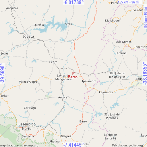
Barro GPS coordinates[2]
6° 43' 0.012" South, 38° 52' 0.012" West
| Map corner | latitude | longitude |
|---|---|---|
| Upper-left | -6.01789°, | -39.5698° |
| Center: | -6.71667°, | -38.86667° |
| Lower-right: | -7.41445°, | -38.16355° |
| Map W x H: | 155.3×155.3 km | = 96.5×96.5mi |
| max Lat: | 2.81972° ⇑18% North |
| Barro: | -6.71667° |
| min Lat: | ⇓82% South -33.69111° |
| min Long | Barro | max Long |
| -72.89583° | -38.86667° | -32.41083° |
| W 81.1%⇐ | ⇒18.9% E |
Elevation
Elevation of Barro is 290 m = 951 ft, and this is 90.9 m = 298 ft below average elevation for this country.
| Max E: |
1603 m = 5259 ft | 53.7% |
| Avg. | 380.9 m = 1250 ft | |
| Barro | 290 m = 951 ft | |
Min E: |
0 m = 0 ft | 46.3% |
See also: Brazil elevation on elevation.city.
Geographical zone
Barro is located in South Torrid zone (between Equator and Tropic of Capricorn). Distance of Equator is 746.8 km =464 mi to North.| Distance of | km | miles | from Barro |
|---|---|---|---|
| Equator | 746.8 | 464 | to North |
| Tropic Capricorn | 1859.1 | 1155.2 | to South |
| Antarctic Circle | 6654.4 | 4134.9 | to South |
| South Pole | 9260.2 | 5754 | to South |


Nearby cities:
15 places around Barro: (largest is in red/bold)
• Aurora
27.5 km =17.1 mi,  203°
203°
• Cajazeiras
39.4 km =24.5 mi,  119°
119°
• Caririaçu
58.6 km =36.4 mi,  231°
231°
• Cedro
24.8 km =15.4 mi,  299°
299°
• Icó
35.1 km =21.8 mi,  0°
0°
• Iguatu
62.1 km =38.6 mi,  309°
309°
• Lavras da Mangabeira
11.5 km =7.1 mi,  249°
249°
• Milagres
66.9 km =41.6 mi,  187°
187°
• Missão Velha
66.7 km =41.4 mi,  207°
207°
• Orós
52.8 km =32.8 mi,  354°
354°
• Serra Branca
69.3 km =43.1 mi,  72°
72°
• Sousa
70.7 km =43.9 mi,  93°
93°
• São José de Piranhas
60.3 km =37.5 mi,  138°
138°
• Triunfo
33.8 km =21 mi,  60°
60°
• Uiraúna
54.8 km =34.1 mi, 66°
Sources, notices
• [Note1] Compared only with cities in Brazil existing in our database
• [Src1] Map data: © OpenStreetMap contributors (CC-BY-SA)
• [Src2] Other city data from geonames.org with taken over terms of usage.
• [Src3] Geographical zone / Annual Mean Temperature by Robert A. Rohde @ Wikipedia
