Itaueira geodata
Itaueira (Piauí) is a populated place; located in Brazil in America/Fortaleza (GMT-3) time zone. With population of 5,146 people, there are 1906 cities with bigger population in this country. Compared to other cities in Brazil, 77.1% of cities are located further ↓South; 60.2% of cities are located further ←West and 55.3% of cities have higher elevation than Itaueira. Note1


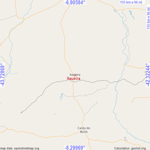
Itaueira GPS coordinates[2]
7° 36' 11.988" South, 43° 1' 32.016" West
| Map corner | latitude | longitude |
|---|---|---|
| Upper-left | -6.90584°, | -43.72869° |
| Center: | -7.60333°, | -43.02556° |
| Lower-right: | -8.29969°, | -42.32244° |
| Map W x H: | 155×155 km | = 96.3×96.3mi |
| max Lat: | 2.81972° ⇑22.9% North |
| Itaueira: | -7.60333° |
| min Lat: | ⇓77.1% South -33.69111° |
| min Long | Itaueira | max Long |
| -72.89583° | -43.02556° | -32.41083° |
| W 60.2%⇐ | ⇒39.8% E |
Elevation
Elevation of Itaueira is 264 m = 866 ft, and this is 116.9 m = 384 ft below average elevation for this country.
| Max E: |
1603 m = 5259 ft | 55.3% |
| Avg. | 380.9 m = 1250 ft | |
| Itaueira | 264 m = 866 ft | |
Min E: |
0 m = 0 ft | 44.7% |
See also: Brazil elevation on elevation.city.
Geographical zone
Itaueira is located in South Torrid zone (between Equator and Tropic of Capricorn). Distance of Equator is 845.4 km =525.3 mi to North.| Distance of | km | miles | from Itaueira |
|---|---|---|---|
| Equator | 845.4 | 525.3 | to North |
| Tropic Capricorn | 1760.5 | 1093.9 | to South |
| Antarctic Circle | 6555.8 | 4073.6 | to South |
| South Pole | 9161.7 | 5692.8 | to South |


Nearby cities:
15 places around Itaueira: (largest is in red/bold)
• Amarante
152.5 km =94.8 mi,  7°
7°
• Canto do Buriti
57 km =35.4 mi,  170°
170°
• Floriano
93 km =57.8 mi,  0°
0°
• Inhuma
178.7 km =111 mi,  54°
54°
• Itainópolis
171.4 km =106.5 mi,  84°
84°
• Oeiras
117.7 km =73.1 mi,  56°
56°
• Paraibano
167.7 km =104.2 mi,  320°
320°
• Pastos Bons
160.8 km =99.9 mi,  313°
313°
• Raposa
175.8 km =109.2 mi, 313°
• Regeneração
157.1 km =97.6 mi, 13°
• Simplício Mendes
126 km =78.3 mi,  102°
102°
• São João do Piauí
120 km =74.6 mi,  134°
134°
• São João dos Patos
144.1 km =89.5 mi,  328°
328°
• São Raimundo Nonato
161 km =100 mi, 167°
• Uruçuí
173.8 km =108 mi,  283°
283°
Sources, notices
• [Note1] Compared only with cities in Brazil existing in our database
• [Src1] Map data: © OpenStreetMap contributors (CC-BY-SA)
• [Src2] Other city data from geonames.org with taken over terms of usage.
• [Src3] Geographical zone / Annual Mean Temperature by Robert A. Rohde @ Wikipedia
