Inhapi geodata
Inhapi (Alagoas) is a populated place; located in Brazil in America/Maceio (GMT-3) time zone. With population of 7,550 people, there are 1800 cities with bigger population in this country. Compared to other cities in Brazil, 70.4% of cities are located further ↓South; 85.6% of cities are located further ←West and 53.9% of cities have lower elevation than Inhapi. Note1


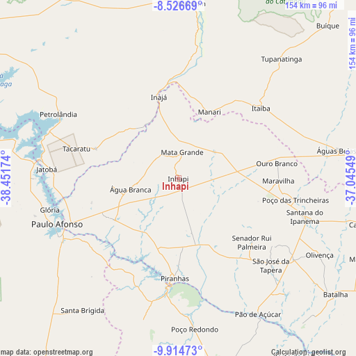
Inhapi GPS coordinates[2]
9° 13' 17.004" South, 37° 44' 54.996" West
| Map corner | latitude | longitude |
|---|---|---|
| Upper-left | -8.52669°, | -38.45174° |
| Center: | -9.22139°, | -37.74861° |
| Lower-right: | -9.91473°, | -37.04549° |
| Map W x H: | 154.3×154.3 km | = 95.9×95.9mi |
| max Lat: | 2.81972° ⇑29.6% North |
| Inhapi: | -9.22139° |
| min Lat: | ⇓70.4% South -33.69111° |
| min Long | Inhapi | max Long |
| -72.89583° | -37.74861° | -32.41083° |
| W 85.6%⇐ | ⇒14.4% E |
Elevation
Elevation of Inhapi is 407 m = 1335 ft, and this is 26.1 m = 86 ft above average elevation for this country.
| Max E: |
1603 m = 5259 ft | 46.1% |
| Inhapi | 407 m 1335 ft | |
| Avg. | 380.9 m = 1250 ft | |
Min E: |
0 m = 0 ft | 53.9% |
See also: Brazil elevation on elevation.city.
Geographical zone
Inhapi is located in South Torrid zone (between Equator and Tropic of Capricorn). Distance of Equator is 1025.3 km =637.1 mi to North.| Distance of | km | miles | from Inhapi |
|---|---|---|---|
| Equator | 1025.3 | 637.1 | to North |
| Tropic Capricorn | 1580.6 | 982.1 | to South |
| Antarctic Circle | 6375.9 | 3961.8 | to South |
| South Pole | 8981.7 | 5581 | to South |


Nearby cities:
15 places around Inhapi: (largest is in red/bold)
• Canindé de São Francisco
49 km =30.4 mi,  185°
185°
• Carnaíba
58.7 km =36.5 mi,  8°
8°
• Delmiro Gouveia
33.2 km =20.6 mi,  235°
235°
• Itaíba
47 km =29.2 mi,  49°
49°
• Jatobá
57.3 km =35.6 mi,  274°
274°
• Mata Grande
11.7 km =7.3 mi, 8°
• Olivença
69.6 km =43.2 mi,  118°
118°
• Paulo Afonso
55.1 km =34.2 mi,  248°
248°
• Poço das Trincheiras
51.8 km =32.2 mi,  101°
101°
• Pão de Açúcar
67.8 km =42.1 mi,  149°
149°
• Santana do Ipanema
57.9 km =36 mi,  107°
107°
• São José da Tapera
55 km =34.2 mi,  132°
132°
• Tupanatinga
68.7 km =42.7 mi,  40°
40°
• Água Branca
21 km =13 mi,  257°
257°
• Águas Belas
69.7 km =43.3 mi,  79°
79°
Sources, notices
• [Note1] Compared only with cities in Brazil existing in our database
• [Src1] Map data: © OpenStreetMap contributors (CC-BY-SA)
• [Src2] Other city data from geonames.org with taken over terms of usage.
• [Src3] Geographical zone / Annual Mean Temperature by Robert A. Rohde @ Wikipedia
