Gurinhém geodata
Gurinhém (Paraíba) is a populated place; located in Brazil in America/Fortaleza (GMT-3) time zone. With population of 5,618 people, there are 1892 cities with bigger population in this country. Compared to other cities in Brazil, 79.8% of cities are located further ↓South; 96.6% of cities are located further ←West and 72.6% of cities have higher elevation than Gurinhém. Note1


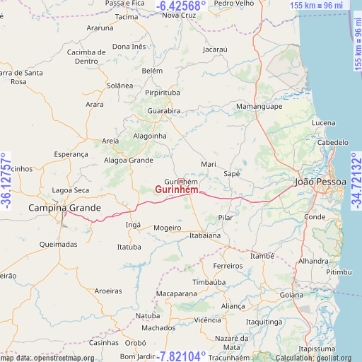
Gurinhém GPS coordinates[2]
7° 7' 26.004" South, 35° 25' 27.984" West
| Map corner | latitude | longitude |
|---|---|---|
| Upper-left | -6.42568°, | -36.12757° |
| Center: | -7.12389°, | -35.42444° |
| Lower-right: | -7.82104°, | -34.72132° |
| Map W x H: | 155.1×155.2 km | = 96.4×96.4mi |
| max Lat: | 2.81972° ⇑20.2% North |
| Gurinhém: | -7.12389° |
| min Lat: | ⇓79.8% South -33.69111° |
| min Long | Gurinhém | max Long |
| -72.89583° | -35.42444° | -32.41083° |
| W 96.6%⇐ | ⇒3.4% E |
Elevation
Elevation of Gurinhém is 98 m = 322 ft, and this is 282.9 m = 928 ft below average elevation for this country.
| Max E: |
1603 m = 5259 ft | 72.6% |
| Avg. | 380.9 m = 1250 ft | |
| Gurinhém | 98 m = 322 ft | |
Min E: |
0 m = 0 ft | 27.4% |
See also: Brazil elevation on elevation.city.
Geographical zone
Gurinhém is located in South Torrid zone (between Equator and Tropic of Capricorn). Distance of Equator is 792.1 km =492.2 mi to North.| Distance of | km | miles | from Gurinhém |
|---|---|---|---|
| Equator | 792.1 | 492.2 | to North |
| Tropic Capricorn | 1813.8 | 1127 | to South |
| Antarctic Circle | 6609.1 | 4106.7 | to South |
| South Pole | 9215 | 5725.9 | to South |


Nearby cities:
15 places around Gurinhém: (largest is in red/bold)
• Alagoa Grande
23 km =14.3 mi,  260°
260°
• Alagoa Nova
37.3 km =23.2 mi,  279°
279°
• Alagoinha
23.5 km =14.6 mi,  325°
325°
• Areia
34.5 km =21.4 mi,  301°
301°
• Cruz do Espírito Santo
37.3 km =23.2 mi,  92°
92°
• Guarabira
30.8 km =19.1 mi,  346°
346°
• Ingá
26.4 km =16.4 mi,  228°
228°
• Itabaiana
24.9 km =15.5 mi,  155°
155°
• Itatuba
35.9 km =22.3 mi,  218°
218°
• Juripiranga
34.5 km =21.4 mi,  143°
143°
• Mari
13.6 km =8.5 mi,  58°
58°
• Mogeiro
20.4 km =12.7 mi,  197°
197°
• Mulungu
11.8 km =7.3 mi,  339°
339°
• Pilar
24.1 km =15 mi,  131°
131°
• Salgado de São Félix
26 km =16.2 mi,  183°
183°
Sources, notices
• [Note1] Compared only with cities in Brazil existing in our database
• [Src1] Map data: © OpenStreetMap contributors (CC-BY-SA)
• [Src2] Other city data from geonames.org with taken over terms of usage.
• [Src3] Geographical zone / Annual Mean Temperature by Robert A. Rohde @ Wikipedia
