Areia geodata
Areia (Paraíba) is a populated place; located in Brazil in America/Fortaleza (GMT-3) time zone. With population of 13,824 people, there are 1305 cities with bigger population in this country. Compared to other cities in Brazil, 80.8% of cities are located further ↓South; 94.6% of cities are located further ←West and 67.2% of cities have lower elevation than Areia. Note1


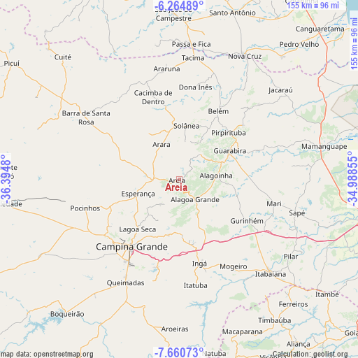
Areia GPS coordinates[2]
6° 57' 47.988" South, 35° 41' 30.012" West
| Map corner | latitude | longitude |
|---|---|---|
| Upper-left | -6.26489°, | -36.3948° |
| Center: | -6.96333°, | -35.69167° |
| Lower-right: | -7.66073°, | -34.98855° |
| Map W x H: | 155.2×155.2 km | = 96.4×96.4mi |
| max Lat: | 2.81972° ⇑19.2% North |
| Areia: | -6.96333° |
| min Lat: | ⇓80.8% South -33.69111° |
| min Long | Areia | max Long |
| -72.89583° | -35.69167° | -32.41083° |
| W 94.6%⇐ | ⇒5.4% E |
Elevation
Elevation of Areia is 546 m = 1791 ft, and this is 165.1 m = 542 ft above average elevation for this country.
| Max E: |
1603 m = 5259 ft | 32.8% |
| Areia | 546 m 1791 ft | |
| Avg. | 380.9 m = 1250 ft | |
Min E: |
0 m = 0 ft | 67.2% |
See also: Brazil elevation on elevation.city.
Geographical zone
Areia is located in South Torrid zone (between Equator and Tropic of Capricorn). Distance of Equator is 774.2 km =481.1 mi to North.| Distance of | km | miles | from Areia |
|---|---|---|---|
| Equator | 774.2 | 481.1 | to North |
| Tropic Capricorn | 1831.7 | 1138.2 | to South |
| Antarctic Circle | 6626.9 | 4117.8 | to South |
| South Pole | 9232.8 | 5737 | to South |


Nearby cities:
15 places around Areia: (largest is in red/bold)
• Alagoa Grande
22.7 km =14.1 mi,  162°
162°
• Alagoa Nova
14 km =8.7 mi,  211°
211°
• Alagoinha
16.3 km =10.1 mi,  84°
84°
• Arara
16.7 km =10.4 mi,  333°
333°
• Bananeiras
24.6 km =15.3 mi,  15°
15°
• Belém
34.9 km =21.7 mi,  30°
30°
• Esperança
19.8 km =12.3 mi,  247°
247°
• Guarabira
25.3 km =15.7 mi,  61°
61°
• Gurinhém
34.5 km =21.4 mi,  121°
121°
• Lagoa Seca
29.2 km =18.1 mi,  217°
217°
• Massaranduba
28.5 km =17.7 mi,  202°
202°
• Mulungu
26.2 km =16.3 mi,  105°
105°
• Pirpirituba
29.5 km =18.3 mi,  46°
46°
• Remígio
10 km =6.2 mi,  280°
280°
• Solânea
28.6 km =17.8 mi,  35°
35°
Sources, notices
• [Note1] Compared only with cities in Brazil existing in our database
• [Src1] Map data: © OpenStreetMap contributors (CC-BY-SA)
• [Src2] Other city data from geonames.org with taken over terms of usage.
• [Src3] Geographical zone / Annual Mean Temperature by Robert A. Rohde @ Wikipedia
