Guarabira geodata
Guarabira (Paraíba) is a populated place; located in Brazil in America/Fortaleza (GMT-3) time zone. With population of 43,749 people, there are 488 cities with bigger population in this country. Compared to other cities in Brazil, 81.2% of cities are located further ↓South; 96% of cities are located further ←West and 73.1% of cities have higher elevation than Guarabira. Note1


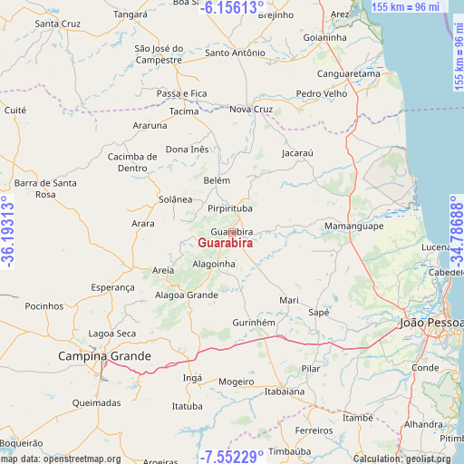
Guarabira GPS coordinates[2]
6° 51' 16.992" South, 35° 29' 24" West
| Map corner | latitude | longitude |
|---|---|---|
| Upper-left | -6.15613°, | -36.19313° |
| Center: | -6.85472°, | -35.49° |
| Lower-right: | -7.55229°, | -34.78688° |
| Map W x H: | 155.2×155.2 km | = 96.4×96.4mi |
| max Lat: | 2.81972° ⇑18.8% North |
| Guarabira: | -6.85472° |
| min Lat: | ⇓81.2% South -33.69111° |
| min Long | Guarabira | max Long |
| -72.89583° | -35.49° | -32.41083° |
| W 96%⇐ | ⇒4% E |
Elevation
Elevation of Guarabira is 94 m = 308 ft, and this is 286.9 m = 941 ft below average elevation for this country.
| Max E: |
1603 m = 5259 ft | 73.1% |
| Avg. | 380.9 m = 1250 ft | |
| Guarabira | 94 m = 308 ft | |
Min E: |
0 m = 0 ft | 26.9% |
See also: Guarabira elevation on elevation.city.
Geographical zone
Guarabira is located in South Torrid zone (between Equator and Tropic of Capricorn). Distance of Equator is 762.2 km =473.6 mi to North.| Distance of | km | miles | from Guarabira |
|---|---|---|---|
| Equator | 762.2 | 473.6 | to North |
| Tropic Capricorn | 1843.7 | 1145.6 | to South |
| Antarctic Circle | 6639 | 4125.3 | to South |
| South Pole | 9244.9 | 5744.5 | to South |


Nearby cities:
15 places around Guarabira: (largest is in red/bold)
• Alagoa Grande
37.1 km =23.1 mi,  204°
204°
• Alagoa Nova
38.1 km =23.7 mi,  230°
230°
• Alagoinha
12.2 km =7.6 mi,  209°
209°
• Arara
29.8 km =18.5 mi,  275°
275°
• Areia
25.3 km =15.7 mi,  241°
241°
• Bananeiras
19.6 km =12.2 mi,  306°
306°
• Belém
18.8 km =11.7 mi,  345°
345°
• Dona Inês
30.8 km =19.1 mi,  330°
330°
• Gurinhém
30.8 km =19.1 mi,  166°
166°
• Jacaraú
34.7 km =21.6 mi,  38°
38°
• Mari
29.6 km =18.4 mi,  140°
140°
• Mulungu
19.1 km =11.9 mi, 170°
• Pirpirituba
8.4 km =5.2 mi, 353°
• Remígio
33.6 km =20.9 mi,  252°
252°
• Solânea
12.4 km =7.7 mi, 333°
Sources, notices
• [Note1] Compared only with cities in Brazil existing in our database
• [Src1] Map data: © OpenStreetMap contributors (CC-BY-SA)
• [Src2] Other city data from geonames.org with taken over terms of usage.
• [Src3] Geographical zone / Annual Mean Temperature by Robert A. Rohde @ Wikipedia
