Ingá geodata
Ingá (Paraíba) is a populated place; located in Brazil in America/Fortaleza (GMT-3) time zone. With population of 8,751 people, there are 1739 cities with bigger population in this country. Compared to other cities in Brazil, 78.8% of cities are located further ↓South; 95.1% of cities are located further ←West and 66.5% of cities have higher elevation than Ingá. Note1


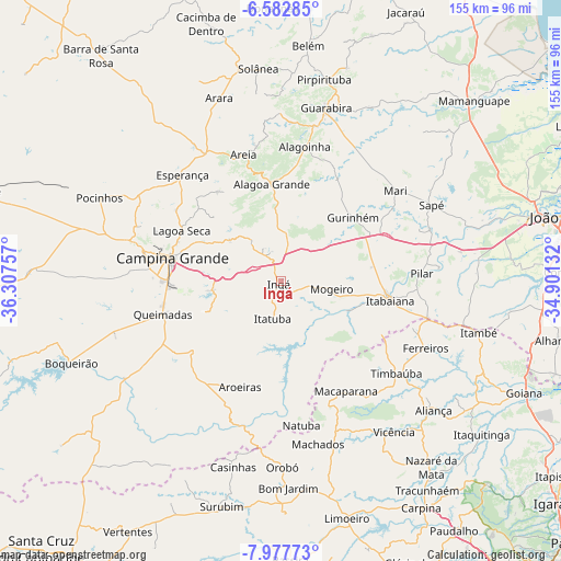
Ingá GPS coordinates[2]
7° 16' 50.988" South, 35° 36' 15.984" West
| Map corner | latitude | longitude |
|---|---|---|
| Upper-left | -6.58285°, | -36.30757° |
| Center: | -7.28083°, | -35.60444° |
| Lower-right: | -7.97773°, | -34.90132° |
| Map W x H: | 155.1×155.1 km | = 96.4×96.4mi |
| max Lat: | 2.81972° ⇑21.2% North |
| Ingá: | -7.28083° |
| min Lat: | ⇓78.8% South -33.69111° |
| min Long | Ingá | max Long |
| -72.89583° | -35.60444° | -32.41083° |
| W 95.1%⇐ | ⇒4.9% E |
Elevation
Elevation of Ingá is 155 m = 509 ft, and this is 225.9 m = 741 ft below average elevation for this country.
| Max E: |
1603 m = 5259 ft | 66.5% |
| Avg. | 380.9 m = 1250 ft | |
| Ingá | 155 m = 509 ft | |
Min E: |
0 m = 0 ft | 33.5% |
See also: Brazil elevation on elevation.city.
Geographical zone
Ingá is located in South Torrid zone (between Equator and Tropic of Capricorn). Distance of Equator is 809.6 km =503.1 mi to North.| Distance of | km | miles | from Ingá |
|---|---|---|---|
| Equator | 809.6 | 503.1 | to North |
| Tropic Capricorn | 1796.4 | 1116.2 | to South |
| Antarctic Circle | 6591.6 | 4095.8 | to South |
| South Pole | 9197.5 | 5715.1 | to South |


Nearby cities:
15 places around Ingá: (largest is in red/bold)
• Alagoa Grande
13.9 km =8.6 mi,  348°
348°
• Alagoa Nova
28.9 km =18 mi,  323°
323°
• Areia
36.6 km =22.7 mi,  344°
344°
• Aroeiras
31.5 km =19.6 mi,  201°
201°
• Campina Grande
31 km =19.3 mi,  280°
280°
• Fagundes
20.5 km =12.7 mi,  246°
246°
• Gurinhém
26.4 km =16.4 mi,  48°
48°
• Itabaiana
30.5 km =19 mi,  100°
100°
• Itatuba
10.8 km =6.7 mi,  194°
194°
• Lagoa Seca
30.1 km =18.7 mi,  293°
293°
• Macaparana
34.7 km =21.6 mi,  151°
151°
• Massaranduba
22.3 km =13.9 mi, 293°
• Mogeiro
13.9 km =8.6 mi, 98°
• Mulungu
32.6 km =20.3 mi,  28°
28°
• Salgado de São Félix
20 km =12.4 mi,  115°
115°
Sources, notices
• [Note1] Compared only with cities in Brazil existing in our database
• [Src1] Map data: © OpenStreetMap contributors (CC-BY-SA)
• [Src2] Other city data from geonames.org with taken over terms of usage.
• [Src3] Geographical zone / Annual Mean Temperature by Robert A. Rohde @ Wikipedia
