Beberibe geodata
Beberibe (Ceará) is a populated place; located in Brazil in America/Fortaleza (GMT-3) time zone. With population of 37,025 people, there are 558 cities with bigger population in this country. Compared to other cities in Brazil, 90.7% of cities are located further ↓South; 84% of cities are located further ←West and 88.9% of cities have higher elevation than Beberibe. Note1


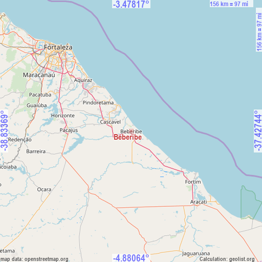
Beberibe GPS coordinates[2]
4° 10' 46.992" South, 38° 7' 50.016" West
| Map corner | latitude | longitude |
|---|---|---|
| Upper-left | -3.47817°, | -38.83369° |
| Center: | -4.17972°, | -38.13056° |
| Lower-right: | -4.88064°, | -37.42744° |
| Map W x H: | 155.9×155.9 km | = 96.9×96.9mi |
| max Lat: | 2.81972° ⇑9.3% North |
| Beberibe: | -4.17972° |
| min Lat: | ⇓90.7% South -33.69111° |
| min Long | Beberibe | max Long |
| -72.89583° | -38.13056° | -32.41083° |
| W 84%⇐ | ⇒16% E |
Elevation
Elevation of Beberibe is 20 m = 66 ft, and this is 360.9 m = 1184 ft below average elevation for this country.
| Max E: |
1603 m = 5259 ft | 88.9% |
| Avg. | 380.9 m = 1250 ft | |
| Beberibe | 20 m = 66 ft | |
Min E: |
0 m = 0 ft | 11.1% |
See also: Brazil elevation on elevation.city.
Geographical zone
Beberibe is located in South Torrid zone (between Equator and Tropic of Capricorn). Distance of Equator is 464.7 km =288.8 mi to North.| Distance of | km | miles | from Beberibe |
|---|---|---|---|
| Equator | 464.7 | 288.8 | to North |
| Tropic Capricorn | 2141.2 | 1330.5 | to South |
| Antarctic Circle | 6936.4 | 4310.1 | to South |
| South Pole | 9542.3 | 5929.3 | to South |


Nearby cities:
15 places around Beberibe: (largest is in red/bold)
• Aquiraz
42.3 km =26.3 mi,  316°
316°
• Aracati
58.3 km =36.2 mi,  136°
136°
• Cascavel
13.4 km =8.3 mi,  292°
292°
• Caucaia
76.1 km =47.3 mi,  310°
310°
• Chorozinho
42.9 km =26.7 mi,  251°
251°
• Eusébio
47.9 km =29.8 mi, 312°
• Fortaleza
68.8 km =42.8 mi, 318°
• Guaiúba
58.3 km =36.2 mi, 285°
• Horizonte
40.1 km =24.9 mi,  282°
282°
• Itaitinga
49.9 km =31 mi,  297°
297°
• Maracanaú
64.4 km =40 mi, 301°
• Ocara
62.2 km =38.6 mi,  236°
236°
• Pacajus
36.6 km =22.7 mi,  271°
271°
• Pacatuba
58.5 km =36.4 mi, 291°
• Redenção
66.7 km =41.4 mi, 265°
Sources, notices
• [Note1] Compared only with cities in Brazil existing in our database
• [Src1] Map data: © OpenStreetMap contributors (CC-BY-SA)
• [Src2] Other city data from geonames.org with taken over terms of usage.
• [Src3] Geographical zone / Annual Mean Temperature by Robert A. Rohde @ Wikipedia
