Baraúna geodata
Baraúna (Rio Grande do Norte) is a populated place; located in Brazil in America/Fortaleza (GMT-3) time zone. With population of 14,112 people, there are 1283 cities with bigger population in this country. Compared to other cities in Brazil, 88.6% of cities are located further ↓South; 86.3% of cities are located further ←West and 72.7% of cities have higher elevation than Baraúna. Note1


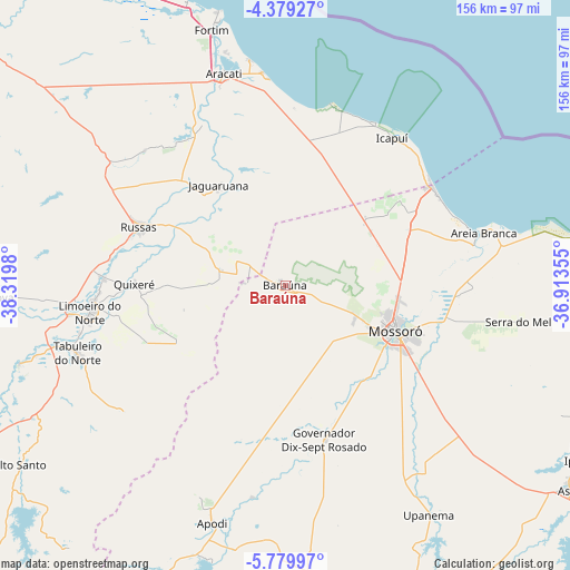
Baraúna GPS coordinates[2]
5° 4' 48" South, 37° 37' 0.012" West
| Map corner | latitude | longitude |
|---|---|---|
| Upper-left | -4.37927°, | -38.3198° |
| Center: | -5.08°, | -37.61667° |
| Lower-right: | -5.77997°, | -36.91355° |
| Map W x H: | 155.7×155.7 km | = 96.7×96.7mi |
| max Lat: | 2.81972° ⇑11.4% North |
| Baraúna: | -5.08° |
| min Lat: | ⇓88.6% South -33.69111° |
| min Long | Baraúna | max Long |
| -72.89583° | -37.61667° | -32.41083° |
| W 86.3%⇐ | ⇒13.7% E |
Elevation
Elevation of Baraúna is 97 m = 318 ft, and this is 283.9 m = 931 ft below average elevation for this country.
| Max E: |
1603 m = 5259 ft | 72.7% |
| Avg. | 380.9 m = 1250 ft | |
| Baraúna | 97 m = 318 ft | |
Min E: |
0 m = 0 ft | 27.3% |
See also: Brazil elevation on elevation.city.
Geographical zone
Baraúna is located in South Torrid zone (between Equator and Tropic of Capricorn). Distance of Equator is 564.8 km =351 mi to North.| Distance of | km | miles | from Baraúna |
|---|---|---|---|
| Equator | 564.8 | 351 | to North |
| Tropic Capricorn | 2041.1 | 1268.3 | to South |
| Antarctic Circle | 6836.3 | 4247.9 | to South |
| South Pole | 9442.2 | 5867.1 | to South |


Nearby cities:
15 places around Baraúna: (largest is in red/bold)
• Apodi
68 km =42.3 mi,  197°
197°
• Aracati
60.1 km =37.3 mi,  343°
343°
• Areia Branca
54.9 km =34.1 mi,  75°
75°
• Açu
95.9 km =59.6 mi,  125°
125°
• Caraúbas
79.5 km =49.4 mi,  175°
175°
• Governador Dix Sept Rosado
43.4 km =27 mi,  165°
165°
• Ipanguaçu
96.3 km =59.8 mi,  118°
118°
• Jaguaruana
32.9 km =20.4 mi,  326°
326°
• Limoeiro do Norte
53.8 km =33.4 mi,  262°
262°
• Morada Nova
83.8 km =52.1 mi,  267°
267°
• Mossoró
32.5 km =20.2 mi,  111°
111°
• Quixeré
41.2 km =25.6 mi, 270°
• Russas
42.7 km =26.5 mi,  291°
291°
• Severiano Melo
86.2 km =53.6 mi,  205°
205°
• Upanema
74 km =46 mi,  147°
147°
Sources, notices
• [Note1] Compared only with cities in Brazil existing in our database
• [Src1] Map data: © OpenStreetMap contributors (CC-BY-SA)
• [Src2] Other city data from geonames.org with taken over terms of usage.
• [Src3] Geographical zone / Annual Mean Temperature by Robert A. Rohde @ Wikipedia
