Arara geodata
Arara (Paraíba) is a populated place; located in Brazil in America/Fortaleza (GMT-3) time zone. With population of 7,641 people, there are 1792 cities with bigger population in this country. Compared to other cities in Brazil, 81.4% of cities are located further ↓South; 94.1% of cities are located further ←West and 58.6% of cities have lower elevation than Arara. Note1


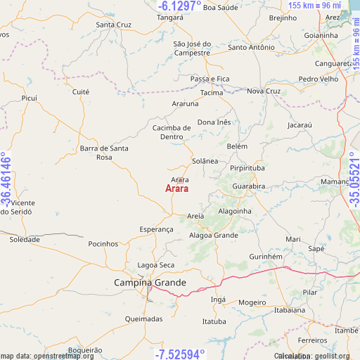
Arara GPS coordinates[2]
6° 49' 41.988" South, 35° 45' 29.988" West
| Map corner | latitude | longitude |
|---|---|---|
| Upper-left | -6.1297°, | -36.46146° |
| Center: | -6.82833°, | -35.75833° |
| Lower-right: | -7.52594°, | -35.05521° |
| Map W x H: | 155.2×155.3 km | = 96.4×96.5mi |
| max Lat: | 2.81972° ⇑18.6% North |
| Arara: | -6.82833° |
| min Lat: | ⇓81.4% South -33.69111° |
| min Long | Arara | max Long |
| -72.89583° | -35.75833° | -32.41083° |
| W 94.1%⇐ | ⇒5.9% E |
Elevation
Elevation of Arara is 461 m = 1512 ft, and this is 80.1 m = 263 ft above average elevation for this country.
| Max E: |
1603 m = 5259 ft | 41.4% |
| Arara | 461 m 1512 ft | |
| Avg. | 380.9 m = 1250 ft | |
Min E: |
0 m = 0 ft | 58.6% |
See also: Brazil elevation on elevation.city.
Geographical zone
Arara is located in South Torrid zone (between Equator and Tropic of Capricorn). Distance of Equator is 759.2 km =471.7 mi to North.| Distance of | km | miles | from Arara |
|---|---|---|---|
| Equator | 759.2 | 471.7 | to North |
| Tropic Capricorn | 1846.7 | 1147.5 | to South |
| Antarctic Circle | 6641.9 | 4127.1 | to South |
| South Pole | 9247.8 | 5746.3 | to South |


Nearby cities:
15 places around Arara: (largest is in red/bold)
• Alagoa Grande
39.3 km =24.4 mi,  158°
158°
• Alagoa Nova
27 km =16.8 mi,  180°
180°
• Alagoinha
27.2 km =16.9 mi,  119°
119°
• Araruna
30.1 km =18.7 mi,  3°
3°
• Areia
16.7 km =10.4 mi,  153°
153°
• Bananeiras
16.3 km =10.1 mi,  57°
57°
• Belém
29.1 km =18.1 mi, 58°
• Cacimba de Dentro
21 km =13 mi,  350°
350°
• Dona Inês
28 km =17.4 mi,  31°
31°
• Esperança
25.2 km =15.7 mi,  205°
205°
• Guarabira
29.8 km =18.5 mi,  95°
95°
• Mulungu
39.3 km =24.4 mi, 123°
• Pirpirituba
29.2 km =18.1 mi,  79°
79°
• Remígio
13.4 km =8.3 mi,  190°
190°
• Solânea
25.4 km =15.8 mi,  71°
71°
Sources, notices
• [Note1] Compared only with cities in Brazil existing in our database
• [Src1] Map data: © OpenStreetMap contributors (CC-BY-SA)
• [Src2] Other city data from geonames.org with taken over terms of usage.
• [Src3] Geographical zone / Annual Mean Temperature by Robert A. Rohde @ Wikipedia
