Esperança geodata
Esperança (Paraíba) is a populated place; located in Brazil in America/Fortaleza (GMT-3) time zone. With population of 18,817 people, there are 994 cities with bigger population in this country. Compared to other cities in Brazil, 80.4% of cities are located further ↓South; 93.3% of cities are located further ←West and 73.7% of cities have lower elevation than Esperança. Note1


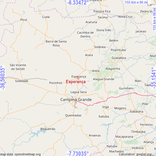
Esperança GPS coordinates[2]
7° 1' 59.016" South, 35° 51' 25.992" West
| Map corner | latitude | longitude |
|---|---|---|
| Upper-left | -6.33472°, | -36.56035° |
| Center: | -7.03306°, | -35.85722° |
| Lower-right: | -7.73035°, | -35.1541° |
| Map W x H: | 155.2×155.2 km | = 96.4×96.4mi |
| max Lat: | 2.81972° ⇑19.6% North |
| Esperança: | -7.03306° |
| min Lat: | ⇓80.4% South -33.69111° |
| min Long | Esperança | max Long |
| -72.89583° | -35.85722° | -32.41083° |
| W 93.3%⇐ | ⇒6.7% E |
Elevation
Elevation of Esperança is 610 m = 2001 ft, and this is 229.1 m = 752 ft above average elevation for this country.
| Max E: |
1603 m = 5259 ft | 26.3% |
| Esperança | 610 m 2001 ft | |
| Avg. | 380.9 m = 1250 ft | |
Min E: |
0 m = 0 ft | 73.7% |
See also: Brazil elevation on elevation.city.
Geographical zone
Esperança is located in South Torrid zone (between Equator and Tropic of Capricorn). Distance of Equator is 782 km =485.9 mi to North.| Distance of | km | miles | from Esperança |
|---|---|---|---|
| Equator | 782 | 485.9 | to North |
| Tropic Capricorn | 1823.9 | 1133.3 | to South |
| Antarctic Circle | 6619.2 | 4113 | to South |
| South Pole | 9225.1 | 5732.2 | to South |


Nearby cities:
15 places around Esperança: (largest is in red/bold)
• Alagoa Grande
28.7 km =17.8 mi,  119°
119°
• Alagoa Nova
11.7 km =7.3 mi,  111°
111°
• Alagoinha
35.7 km =22.2 mi,  74°
74°
• Arara
25.2 km =15.7 mi,  25°
25°
• Areia
19.8 km =12.3 mi, 67°
• Bananeiras
40 km =24.9 mi,  38°
38°
• Campina Grande
22.1 km =13.7 mi,  186°
186°
• Fagundes
36.9 km =22.9 mi,  165°
165°
• Ingá
39.2 km =24.4 mi,  134°
134°
• Lagoa Seca
15.3 km =9.5 mi,  178°
178°
• Massaranduba
20.1 km =12.5 mi,  158°
158°
• Mulungu
43.6 km =27.1 mi,  88°
88°
• Pocinhos
23 km =14.3 mi,  257°
257°
• Puxinanã
18.2 km =11.3 mi,  218°
218°
• Remígio
12.8 km =8 mi, 41°
Sources, notices
• [Note1] Compared only with cities in Brazil existing in our database
• [Src1] Map data: © OpenStreetMap contributors (CC-BY-SA)
• [Src2] Other city data from geonames.org with taken over terms of usage.
• [Src3] Geographical zone / Annual Mean Temperature by Robert A. Rohde @ Wikipedia
