Viamão geodata
Viamão (Rio Grande do Sul) is a populated place; located in Brazil in America/Sao_Paulo (GMT-3) time zone. With population of 285,269 people, there are 78 cities with bigger population in this country. Compared to other cities in Brazil, 98.8% of cities are located further ↑North; 82.5% of cities are located further →East and 71.7% of cities have higher elevation than Viamão. Note1


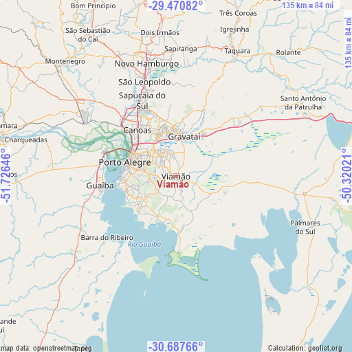
Viamão GPS coordinates[2]
30° 4' 51.996" South, 51° 1' 23.988" West
| Map corner | latitude | longitude |
|---|---|---|
| Upper-left | -29.47082°, | -51.72646° |
| Center: | -30.08111°, | -51.02333° |
| Lower-right: | -30.68766°, | -50.32021° |
| Map W x H: | 135.3×135.3 km | = 84.1×84.1mi |
| max Lat: | 2.81972° ⇑98.8% North |
| Viamão: | -30.08111° |
| min Lat: | ⇓1.2% South -33.69111° |
| min Long | Viamão | max Long |
| -72.89583° | -51.02333° | -32.41083° |
| W 17.5%⇐ | ⇒82.5% E |
Elevation
Elevation of Viamão is 108 m = 354 ft, and this is 272.9 m = 895 ft below average elevation for this country.
| Max E: |
1603 m = 5259 ft | 71.7% |
| Avg. | 380.9 m = 1250 ft | |
| Viamão | 108 m = 354 ft | |
Min E: |
0 m = 0 ft | 28.3% |
See also: Viamão elevation on elevation.city.
Geographical zone
Viamão is located in South temperate zone (between Tropic of Capricorn and the Antarctic Circle). Distance of this Southern Tropic circle is 738.8 km =459.1 mi to North.| Distance of | km | miles | from Viamão |
|---|---|---|---|
| Equator | 3344.7 | 2078.3 | to North |
| Tropic Capricorn | 738.8 | 459.1 | to North |
| Antarctic Circle | 4056.5 | 2520.6 | to South |
| South Pole | 6662.4 | 4139.8 | to South |


Nearby cities:
15 places around Viamão: (largest is in red/bold)
• Cachoeirinha
16 km =9.9 mi,  334°
334°
• Canoas
23.8 km =14.8 mi,  319°
319°
• Esteio
28.7 km =17.8 mi, 328°
• Estância Velha
50.3 km =31.3 mi,  343°
343°
• Gravataí
15.7 km =9.8 mi,  10°
10°
• Guaíba
29.2 km =18.1 mi,  262°
262°
• Novo Hamburgo
46 km =28.6 mi,  347°
347°
• Palmares do Sul
53.1 km =33 mi,  111°
111°
• Parobé
53.5 km =33.2 mi,  19°
19°
• Porto Alegre
20.6 km =12.8 mi,  285°
285°
• Portão
47.2 km =29.3 mi, 333°
• Sapiranga
49.3 km =30.6 mi,  1°
1°
• Sapucaia
30.1 km =18.7 mi, 336°
• São Leopoldo
37.6 km =23.4 mi, 341°
• Taquara
53.3 km =33.1 mi,  26°
26°
Sources, notices
• [Note1] Compared only with cities in Brazil existing in our database
• [Src1] Map data: © OpenStreetMap contributors (CC-BY-SA)
• [Src2] Other city data from geonames.org with taken over terms of usage.
• [Src3] Geographical zone / Annual Mean Temperature by Robert A. Rohde @ Wikipedia
