Porto Alegre geodata
Porto Alegre (Rio Grande do Sul) is a seat of a first-order administrative division; located in Brazil in America/Sao_Paulo (GMT-3) time zone. With population of 1,372,741 people, there are 10 cities with bigger population in this country. Compared to other cities in Brazil, 98.6% of cities are located further ↑North; 84.2% of cities are located further →East and 99.9% of cities have higher elevation than Porto Alegre. Note1


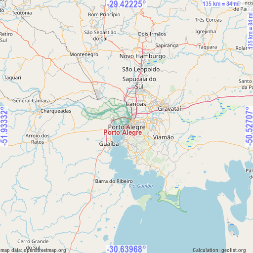
Porto Alegre GPS coordinates[2]
30° 1' 58.188" South, 51° 13' 48.684" West
| Map corner | latitude | longitude |
|---|---|---|
| Upper-left | -29.42225°, | -51.93332° |
| Center: | -30.03283°, | -51.23019° |
| Lower-right: | -30.63968°, | -50.52707° |
| Map W x H: | 135.4×135.4 km | = 84.1×84.1mi |
| max Lat: | 2.81972° ⇑98.6% North |
| Porto Alegre: | -30.03283° |
| min Lat: | ⇓1.4% South -33.69111° |
| min Long | Porto Alegre | max Long |
| -72.89583° | -51.23019° | -32.41083° |
| W 15.8%⇐ | ⇒84.2% E |
Elevation
Elevation of Porto Alegre is 1 m = 3 ft, and this is 379.9 m = 1246 ft below average elevation for this country.
| Max E: |
1603 m = 5259 ft | 99.9% |
| Avg. | 380.9 m = 1250 ft | |
| Porto Alegre | 1 m = 3 ft | |
Min E: |
0 m = 0 ft | 0.1% |
See also: Porto Alegre elevation on elevation.city.
Geographical zone
Porto Alegre is located in South temperate zone (between Tropic of Capricorn and the Antarctic Circle). Distance of this Southern Tropic circle is 733.4 km =455.7 mi to North.| Distance of | km | miles | from Porto Alegre |
|---|---|---|---|
| Equator | 3339.3 | 2074.9 | to North |
| Tropic Capricorn | 733.4 | 455.7 | to North |
| Antarctic Circle | 4061.8 | 2523.9 | to South |
| South Pole | 6667.7 | 4143.1 | to South |


Nearby cities:
15 places around Porto Alegre: (largest is in red/bold)
• Cachoeirinha
16 km =9.9 mi,  55°
55°
• Canoas
13.6 km =8.5 mi,  19°
19°
• Charqueadas
39 km =24.2 mi,  282°
282°
• Esteio
19.7 km =12.2 mi,  14°
14°
• Estância Velha
43.1 km =26.8 mi, 7°
• Gravataí
25 km =15.5 mi,  66°
66°
• Guaíba
12.8 km =8 mi,  225°
225°
• Montenegro
44.3 km =27.5 mi,  329°
329°
• Novo Hamburgo
40.6 km =25.2 mi, 13°
• Portão
36.8 km =22.9 mi,  358°
358°
• Sapucaia
23.5 km =14.6 mi, 19°
• São Jerônimo
48.1 km =29.9 mi, 279°
• São Leopoldo
31.3 km =19.4 mi, 14°
• Triunfo
48 km =29.8 mi, 281°
• Viamão
20.6 km =12.8 mi,  105°
105°
Sources, notices
• [Note1] Compared only with cities in Brazil existing in our database
• [Src1] Map data: © OpenStreetMap contributors (CC-BY-SA)
• [Src2] Other city data from geonames.org with taken over terms of usage.
• [Src3] Geographical zone / Annual Mean Temperature by Robert A. Rohde @ Wikipedia
