Palmares do Sul geodata
Palmares do Sul (Rio Grande do Sul) is a populated place; located in Brazil in America/Sao_Paulo (GMT-3) time zone. With population of 8,392 people, there are 1755 cities with bigger population in this country. Compared to other cities in Brazil, 99% of cities are located further ↑North; 80.4% of cities are located further →East and 99% of cities have higher elevation than Palmares do Sul. Note1


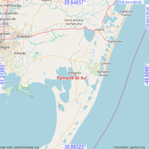
Palmares do Sul GPS coordinates[2]
30° 15' 28.008" South, 50° 30' 34.992" West
| Map corner | latitude | longitude |
|---|---|---|
| Upper-left | -29.64857°, | -51.21285° |
| Center: | -30.25778°, | -50.50972° |
| Lower-right: | -30.86323°, | -49.8066° |
| Map W x H: | 135.1×135.1 km | = 83.9×83.9mi |
| max Lat: | 2.81972° ⇑99% North |
| Palmares do Sul: | -30.25778° |
| min Lat: | ⇓1% South -33.69111° |
| min Long | Palmares do Sul | max Long |
| -72.89583° | -50.50972° | -32.41083° |
| W 19.6%⇐ | ⇒80.4% E |
Elevation
Elevation of Palmares do Sul is 5 m = 16 ft, and this is 375.9 m = 1233 ft below average elevation for this country.
| Max E: |
1603 m = 5259 ft | 99% |
| Avg. | 380.9 m = 1250 ft | |
| Palmares do Sul | 5 m = 16 ft | |
Min E: |
0 m = 0 ft | 1% |
See also: Brazil elevation on elevation.city.
Geographical zone
Palmares do Sul is located in South temperate zone (between Tropic of Capricorn and the Antarctic Circle). Distance of this Southern Tropic circle is 758.4 km =471.2 mi to North.| Distance of | km | miles | from Palmares do Sul |
|---|---|---|---|
| Equator | 3364.3 | 2090.5 | to North |
| Tropic Capricorn | 758.4 | 471.2 | to North |
| Antarctic Circle | 4036.8 | 2508.4 | to South |
| South Pole | 6642.7 | 4127.6 | to South |


Nearby cities:
15 places around Palmares do Sul: (largest is in red/bold)
• Cachoeirinha
65.7 km =40.8 mi,  301°
301°
• Canoas
75.1 km =46.7 mi, 300°
• Capão da Canoa
74.6 km =46.4 mi,  40°
40°
• Cidreira
30.4 km =18.9 mi,  73°
73°
• Esteio
78.1 km =48.5 mi, 304°
• Gravataí
58.2 km =36.2 mi,  307°
307°
• Guaíba
80 km =49.7 mi,  281°
281°
• Osório
47.3 km =29.4 mi,  29°
29°
• Parobé
76.6 km =47.6 mi,  335°
335°
• Porto Alegre
73.7 km =45.8 mi,  289°
289°
• Rolante
67.8 km =42.1 mi,  354°
354°
• Sapucaia
77.6 km =48.2 mi, 307°
• Taquara
72.4 km =45 mi, 338°
• Tramandaí
47.2 km =29.3 mi,  49°
49°
• Viamão
53.1 km =33 mi, 291°
Sources, notices
• [Note1] Compared only with cities in Brazil existing in our database
• [Src1] Map data: © OpenStreetMap contributors (CC-BY-SA)
• [Src2] Other city data from geonames.org with taken over terms of usage.
• [Src3] Geographical zone / Annual Mean Temperature by Robert A. Rohde @ Wikipedia
