Tucano geodata
Tucano (Bahia) is a populated place; located in Brazil in America/Bahia (GMT-3) time zone. With population of 31,203 people, there are 646 cities with bigger population in this country. Compared to other cities in Brazil, 65% of cities are located further ↓South; 81.3% of cities are located further ←West and 59.2% of cities have higher elevation than Tucano. Note1


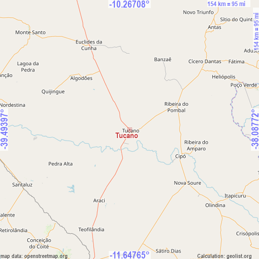
Tucano GPS coordinates[2]
10° 57' 29.412" South, 38° 47' 27.024" West
| Map corner | latitude | longitude |
|---|---|---|
| Upper-left | -10.26708°, | -39.49397° |
| Center: | -10.95817°, | -38.79084° |
| Lower-right: | -11.64765°, | -38.08772° |
| Map W x H: | 153.5×153.5 km | = 95.4×95.4mi |
| max Lat: | 2.81972° ⇑35% North |
| Tucano: | -10.95817° |
| min Lat: | ⇓65% South -33.69111° |
| min Long | Tucano | max Long |
| -72.89583° | -38.79084° | -32.41083° |
| W 81.3%⇐ | ⇒18.7% E |
Elevation
Elevation of Tucano is 222 m = 728 ft, and this is 158.9 m = 521 ft below average elevation for this country.
| Max E: |
1603 m = 5259 ft | 59.2% |
| Avg. | 380.9 m = 1250 ft | |
| Tucano | 222 m = 728 ft | |
Min E: |
0 m = 0 ft | 40.8% |
See also: Brazil elevation on elevation.city.
Geographical zone
Tucano is located in South Torrid zone (between Equator and Tropic of Capricorn). Distance of Equator is 1218.4 km =757.1 mi to North.| Distance of | km | miles | from Tucano |
|---|---|---|---|
| Equator | 1218.4 | 757.1 | to North |
| Tropic Capricorn | 1387.5 | 862.2 | to South |
| Antarctic Circle | 6182.7 | 3841.8 | to South |
| South Pole | 8788.6 | 5461 | to South |


Nearby cities:
15 places around Tucano: (largest is in red/bold)
• Araci
45.9 km =28.5 mi,  204°
204°
• Cipó
34.1 km =21.2 mi,  117°
117°
• Conceição do Coité
86.1 km =53.5 mi,  218°
218°
• Cícero Dantas
59.7 km =37.1 mi,  48°
48°
• Euclides da Cunha
55.8 km =34.7 mi,  333°
333°
• Itapicuru
72.7 km =45.2 mi, 123°
• Monte Santo
82.8 km =51.4 mi,  314°
314°
• Nova Soure
45.4 km =28.2 mi,  132°
132°
• Olindina
67.5 km =41.9 mi, 132°
• Poço Verde
71.9 km =44.7 mi,  67°
67°
• Quijingue
51.1 km =31.8 mi,  296°
296°
• Ribeira do Pombal
31.1 km =19.3 mi,  63°
63°
• Santaluz
71.8 km =44.6 mi,  242°
242°
• Serrinha
82 km =51 mi, 196°
• Valente
88.9 km =55.2 mi, 235°
Sources, notices
• [Note1] Compared only with cities in Brazil existing in our database
• [Src1] Map data: © OpenStreetMap contributors (CC-BY-SA)
• [Src2] Other city data from geonames.org with taken over terms of usage.
• [Src3] Geographical zone / Annual Mean Temperature by Robert A. Rohde @ Wikipedia
