Nova Soure geodata
Nova Soure (Bahia) is a populated place; located in Brazil in America/Bahia (GMT-3) time zone. With population of 11,340 people, there are 1534 cities with bigger population in this country. Compared to other cities in Brazil, 64.4% of cities are located further ↓South; 82.7% of cities are located further ←West and 65.4% of cities have higher elevation than Nova Soure. Note1


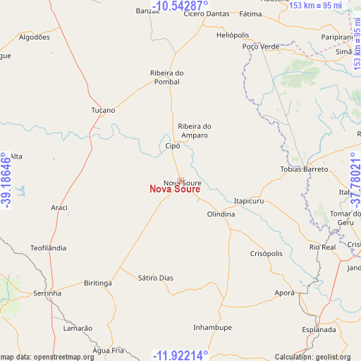
Nova Soure GPS coordinates[2]
11° 13' 59.988" South, 38° 28' 59.988" West
| Map corner | latitude | longitude |
|---|---|---|
| Upper-left | -10.54287°, | -39.18646° |
| Center: | -11.23333°, | -38.48333° |
| Lower-right: | -11.92214°, | -37.78021° |
| Map W x H: | 153.4×153.4 km | = 95.3×95.3mi |
| max Lat: | 2.81972° ⇑35.6% North |
| Nova Soure: | -11.23333° |
| min Lat: | ⇓64.4% South -33.69111° |
| min Long | Nova Soure | max Long |
| -72.89583° | -38.48333° | -32.41083° |
| W 82.7%⇐ | ⇒17.3% E |
Elevation
Elevation of Nova Soure is 164 m = 538 ft, and this is 216.9 m = 712 ft below average elevation for this country.
| Max E: |
1603 m = 5259 ft | 65.4% |
| Avg. | 380.9 m = 1250 ft | |
| Nova Soure | 164 m = 538 ft | |
Min E: |
0 m = 0 ft | 34.6% |
See also: Brazil elevation on elevation.city.
Geographical zone
Nova Soure is located in South Torrid zone (between Equator and Tropic of Capricorn). Distance of Equator is 1249 km =776.1 mi to North.| Distance of | km | miles | from Nova Soure |
|---|---|---|---|
| Equator | 1249 | 776.1 | to North |
| Tropic Capricorn | 1356.9 | 843.1 | to South |
| Antarctic Circle | 6152.1 | 3822.7 | to South |
| South Pole | 8758 | 5442 | to South |


Nearby cities:
15 places around Nova Soure: (largest is in red/bold)
• Acajutiba
69.7 km =43.3 mi,  133°
133°
• Araci
53.9 km =33.5 mi,  258°
258°
• Cipó
15.2 km =9.4 mi,  347°
347°
• Cícero Dantas
71.3 km =44.3 mi,  8°
8°
• Inhambupe
62.9 km =39.1 mi,  166°
166°
• Itabaianinha
75.7 km =47 mi,  93°
93°
• Itapicuru
28.8 km =17.9 mi,  108°
108°
• Olindina
22.1 km =13.7 mi, 132°
• Poço Verde
66.9 km =41.6 mi,  29°
29°
• Ribeira do Pombal
44.7 km =27.8 mi, 352°
• Rio Real
66.2 km =41.1 mi, 114°
• Serrinha
74.6 km =46.4 mi,  230°
230°
• Tobias Barreto
53.2 km =33.1 mi,  84°
84°
• Tomar do Geru
71.8 km =44.6 mi,  102°
102°
• Tucano
45.4 km =28.2 mi,  312°
312°
Sources, notices
• [Note1] Compared only with cities in Brazil existing in our database
• [Src1] Map data: © OpenStreetMap contributors (CC-BY-SA)
• [Src2] Other city data from geonames.org with taken over terms of usage.
• [Src3] Geographical zone / Annual Mean Temperature by Robert A. Rohde @ Wikipedia
