Olindina geodata
Olindina (Bahia) is a populated place; located in Brazil in America/Bahia (GMT-3) time zone. With population of 12,316 people, there are 1450 cities with bigger population in this country. Compared to other cities in Brazil, 64% of cities are located further ↓South; 83.3% of cities are located further ←West and 65% of cities have higher elevation than Olindina. Note1


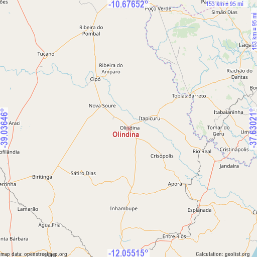
Olindina GPS coordinates[2]
11° 22' 0.012" South, 38° 19' 59.988" West
| Map corner | latitude | longitude |
|---|---|---|
| Upper-left | -10.67652°, | -39.03646° |
| Center: | -11.36667°, | -38.33333° |
| Lower-right: | -12.05515°, | -37.63021° |
| Map W x H: | 153.3×153.3 km | = 95.3×95.3mi |
| max Lat: | 2.81972° ⇑36% North |
| Olindina: | -11.36667° |
| min Lat: | ⇓64% South -33.69111° |
| min Long | Olindina | max Long |
| -72.89583° | -38.33333° | -32.41083° |
| W 83.3%⇐ | ⇒16.7% E |
Elevation
Elevation of Olindina is 166 m = 545 ft, and this is 214.9 m = 705 ft below average elevation for this country.
| Max E: |
1603 m = 5259 ft | 65% |
| Avg. | 380.9 m = 1250 ft | |
| Olindina | 166 m = 545 ft | |
Min E: |
0 m = 0 ft | 35% |
See also: Brazil elevation on elevation.city.
Geographical zone
Olindina is located in South Torrid zone (between Equator and Tropic of Capricorn). Distance of Equator is 1263.9 km =785.4 mi to North.| Distance of | km | miles | from Olindina |
|---|---|---|---|
| Equator | 1263.9 | 785.4 | to North |
| Tropic Capricorn | 1342.1 | 833.9 | to South |
| Antarctic Circle | 6137.3 | 3813.5 | to South |
| South Pole | 8743.2 | 5432.8 | to South |


Nearby cities:
15 places around Olindina: (largest is in red/bold)
• Acajutiba
47.6 km =29.6 mi,  133°
133°
• Araci
69.1 km =42.9 mi,  273°
273°
• Cipó
35.6 km =22.1 mi,  326°
326°
• Cristinápolis
64.2 km =39.9 mi,  100°
100°
• Entre Rios
69.5 km =43.2 mi,  157°
157°
• Esplanada
63.8 km =39.6 mi,  138°
138°
• Inhambupe
46.5 km =28.9 mi,  182°
182°
• Itabaianinha
60.1 km =37.3 mi,  80°
80°
• Itapicuru
12.2 km =7.6 mi,  62°
62°
• Nova Soure
22.1 km =13.7 mi,  312°
312°
• Ribeira do Pombal
63.2 km =39.3 mi,  339°
339°
• Rio Real
45.6 km =28.3 mi,  106°
106°
• Tobias Barreto
41.8 km =26 mi, 60°
• Tomar do Geru
53.7 km =33.4 mi,  90°
90°
• Tucano
67.5 km =41.9 mi, 312°
Sources, notices
• [Note1] Compared only with cities in Brazil existing in our database
• [Src1] Map data: © OpenStreetMap contributors (CC-BY-SA)
• [Src2] Other city data from geonames.org with taken over terms of usage.
• [Src3] Geographical zone / Annual Mean Temperature by Robert A. Rohde @ Wikipedia
