Serrinha geodata
Serrinha (Bahia) is a populated place; located in Brazil in America/Bahia (GMT-3) time zone. With population of 49,078 people, there are 435 cities with bigger population in this country. Compared to other cities in Brazil, 63.2% of cities are located further ↓South; 80.2% of cities are located further ←West and 51.4% of cities have lower elevation than Serrinha. Note1


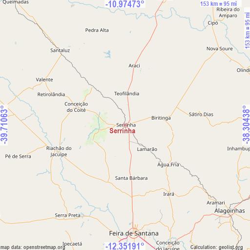
Serrinha GPS coordinates[2]
11° 39' 51.012" South, 39° 0' 27" West
| Map corner | latitude | longitude |
|---|---|---|
| Upper-left | -10.97473°, | -39.71063° |
| Center: | -11.66417°, | -39.0075° |
| Lower-right: | -12.35191°, | -38.30438° |
| Map W x H: | 153.1×153.1 km | = 95.1×95.1mi |
| max Lat: | 2.81972° ⇑36.8% North |
| Serrinha: | -11.66417° |
| min Lat: | ⇓63.2% South -33.69111° |
| min Long | Serrinha | max Long |
| -72.89583° | -39.0075° | -32.41083° |
| W 80.2%⇐ | ⇒19.8% E |
Elevation
Elevation of Serrinha is 368 m = 1207 ft, and this is 12.9 m = 42 ft below average elevation for this country.
| Max E: |
1603 m = 5259 ft | 48.6% |
| Avg. | 380.9 m = 1250 ft | |
| Serrinha | 368 m = 1207 ft | |
Min E: |
0 m = 0 ft | 51.4% |
See also: Serrinha elevation on elevation.city.
Geographical zone
Serrinha is located in South Torrid zone (between Equator and Tropic of Capricorn). Distance of Equator is 1296.9 km =805.9 mi to North.| Distance of | km | miles | from Serrinha |
|---|---|---|---|
| Equator | 1296.9 | 805.9 | to North |
| Tropic Capricorn | 1309 | 813.4 | to South |
| Antarctic Circle | 6104.2 | 3793 | to South |
| South Pole | 8710.1 | 5412.2 | to South |


Nearby cities:
15 places around Serrinha: (largest is in red/bold)
• Anguera
60.1 km =37.3 mi,  205°
205°
• Araci
37.1 km =23.1 mi,  6°
6°
• Cipó
82.7 km =51.4 mi,  40°
40°
• Conceição do Coité
32 km =19.9 mi,  290°
290°
• Conceição do Jacuípe
77.1 km =47.9 mi,  160°
160°
• Coração de Maria
69.2 km =43 mi, 156°
• Feira de Santana
67.1 km =41.7 mi,  176°
176°
• Inhambupe
72.5 km =45 mi,  100°
100°
• Irará
50.3 km =31.3 mi,  148°
148°
• Nova Soure
74.6 km =46.4 mi,  50°
50°
• Olindina
80.6 km =50.1 mi,  65°
65°
• Riachão do Jacuípe
44.1 km =27.4 mi,  248°
248°
• Santaluz
60.5 km =37.6 mi,  318°
318°
• Tucano
82 km =51 mi,  16°
16°
• Valente
56.9 km =35.4 mi,  299°
299°
Sources, notices
• [Note1] Compared only with cities in Brazil existing in our database
• [Src1] Map data: © OpenStreetMap contributors (CC-BY-SA)
• [Src2] Other city data from geonames.org with taken over terms of usage.
• [Src3] Geographical zone / Annual Mean Temperature by Robert A. Rohde @ Wikipedia
