Valente geodata
Valente (Bahia) is a populated place; located in Brazil in America/Bahia (GMT-3) time zone. With population of 12,588 people, there are 1412 cities with bigger population in this country. Compared to other cities in Brazil, 63.7% of cities are located further ↓South; 77.5% of cities are located further ←West and 50.4% of cities have lower elevation than Valente. Note1


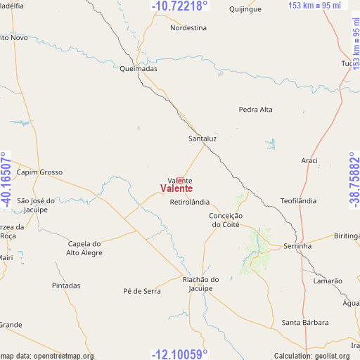
Valente GPS coordinates[2]
11° 24' 43.992" South, 39° 27' 42.984" West
| Map corner | latitude | longitude |
|---|---|---|
| Upper-left | -10.72218°, | -40.16507° |
| Center: | -11.41222°, | -39.46194° |
| Lower-right: | -12.10059°, | -38.75882° |
| Map W x H: | 153.3×153.3 km | = 95.3×95.3mi |
| max Lat: | 2.81972° ⇑36.3% North |
| Valente: | -11.41222° |
| min Lat: | ⇓63.7% South -33.69111° |
| min Long | Valente | max Long |
| -72.89583° | -39.46194° | -32.41083° |
| W 77.5%⇐ | ⇒22.5% E |
Elevation
Elevation of Valente is 357 m = 1171 ft, and this is 23.9 m = 78 ft below average elevation for this country.
| Max E: |
1603 m = 5259 ft | 49.6% |
| Avg. | 380.9 m = 1250 ft | |
| Valente | 357 m = 1171 ft | |
Min E: |
0 m = 0 ft | 50.4% |
See also: Brazil elevation on elevation.city.
Geographical zone
Valente is located in South Torrid zone (between Equator and Tropic of Capricorn). Distance of Equator is 1268.9 km =788.5 mi to North.| Distance of | km | miles | from Valente |
|---|---|---|---|
| Equator | 1268.9 | 788.5 | to North |
| Tropic Capricorn | 1337 | 830.8 | to South |
| Antarctic Circle | 6132.3 | 3810.4 | to South |
| South Pole | 8738.1 | 5429.6 | to South |


Nearby cities:
15 places around Valente: (largest is in red/bold)
• Anguera
85.4 km =53.1 mi,  164°
164°
• Araci
54.7 km =34 mi,  80°
80°
• Baixa Grande
98.1 km =61 mi,  231°
231°
• Capim Grosso
60.1 km =37.3 mi,  273°
273°
• Conceição do Coité
25.8 km =16 mi,  130°
130°
• Ipirá
88.2 km =54.8 mi,  199°
199°
• Irará
103.7 km =64.4 mi, 133°
• Mairi
81.9 km =50.9 mi,  246°
246°
• Ponto Novo
95.4 km =59.3 mi,  309°
309°
• Queimadas
51.5 km =32 mi,  339°
339°
• Quijingue
78.4 km =48.7 mi,  20°
20°
• Riachão do Jacuípe
44.7 km =27.8 mi,  169°
169°
• Santaluz
19.8 km =12.3 mi,  28°
28°
• Serrinha
56.9 km =35.4 mi,  119°
119°
• Tucano
88.9 km =55.2 mi,  55°
55°
Sources, notices
• [Note1] Compared only with cities in Brazil existing in our database
• [Src1] Map data: © OpenStreetMap contributors (CC-BY-SA)
• [Src2] Other city data from geonames.org with taken over terms of usage.
• [Src3] Geographical zone / Annual Mean Temperature by Robert A. Rohde @ Wikipedia
