Sapucaia geodata
Sapucaia (Rio de Janeiro) is a populated place; located in Brazil in America/Sao_Paulo (GMT-3) time zone. With population of 12,329 people, there are 1449 cities with bigger population in this country. Compared to other cities in Brazil, 70% of cities are located further ↑North; 60.9% of cities are located further ←West and 58.8% of cities have higher elevation than Sapucaia. Note1


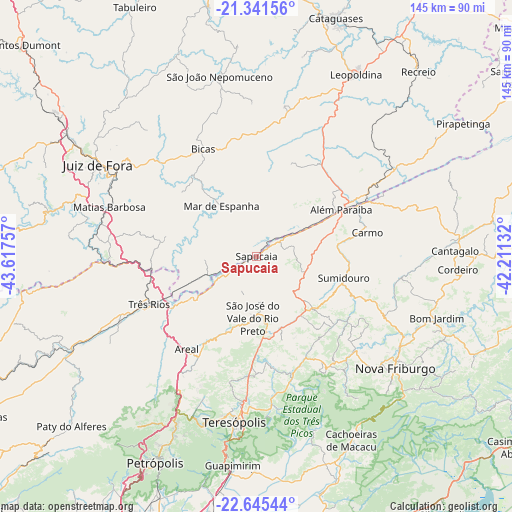
Sapucaia GPS coordinates[2]
21° 59' 42" South, 42° 54' 51.984" West
| Map corner | latitude | longitude |
|---|---|---|
| Upper-left | -21.34156°, | -43.61757° |
| Center: | -21.995°, | -42.91444° |
| Lower-right: | -22.64544°, | -42.21132° |
| Map W x H: | 145×145 km | = 90.1×90.1mi |
| max Lat: | 2.81972° ⇑70% North |
| Sapucaia: | -21.995° |
| min Lat: | ⇓30% South -33.69111° |
| min Long | Sapucaia | max Long |
| -72.89583° | -42.91444° | -32.41083° |
| W 60.9%⇐ | ⇒39.1% E |
Elevation
Elevation of Sapucaia is 224 m = 735 ft, and this is 156.9 m = 515 ft below average elevation for this country.
| Max E: |
1603 m = 5259 ft | 58.8% |
| Avg. | 380.9 m = 1250 ft | |
| Sapucaia | 224 m = 735 ft | |
Min E: |
0 m = 0 ft | 41.2% |
See also: Brazil elevation on elevation.city.
Geographical zone
Sapucaia is located in South Torrid zone (between Equator and Tropic of Capricorn). Distance of this Southern Tropic circle is 160.3 km =99.6 mi to South.| Distance of | km | miles | from Sapucaia |
|---|---|---|---|
| Equator | 2445.6 | 1519.6 | to North |
| Tropic Capricorn | 160.3 | 99.6 | to South |
| Antarctic Circle | 4955.6 | 3079.3 | to South |
| South Pole | 7561.4 | 4698.4 | to South |


Nearby cities:
15 places around Sapucaia: (largest is in red/bold)
• Além Paraíba
24.7 km =15.3 mi,  61°
61°
• Areal
32.8 km =20.4 mi,  216°
216°
• Bicas
33.5 km =20.8 mi,  333°
333°
• Cantagalo
56.4 km =35 mi,  88°
88°
• Carmo
32.3 km =20.1 mi,  77°
77°
• Cordeiro
57.2 km =35.5 mi, 93°
• Juiz de Fora
51.8 km =32.2 mi,  299°
299°
• Mar de Espanha
17.3 km =10.7 mi, 325°
• Matias Barbosa
44.1 km =27.4 mi,  288°
288°
• Nova Friburgo
50.8 km =31.6 mi,  128°
128°
• Paraíba do Sul
43.1 km =26.8 mi,  245°
245°
• São João Nepomuceno
51.6 km =32.1 mi,  348°
348°
• São Pedro
47.9 km =29.8 mi,  186°
186°
• Teresópolis
47.3 km =29.4 mi, 187°
• Três Rios
33.2 km =20.6 mi, 245°
Sources, notices
• [Note1] Compared only with cities in Brazil existing in our database
• [Src1] Map data: © OpenStreetMap contributors (CC-BY-SA)
• [Src2] Other city data from geonames.org with taken over terms of usage.
• [Src3] Geographical zone / Annual Mean Temperature by Robert A. Rohde @ Wikipedia
