Paraíba do Sul geodata
Paraíba do Sul (Rio de Janeiro) is a seat of a third-order administrative division; located in Brazil in America/Sao_Paulo (GMT-3) time zone. With population of 35,517 people, there are 577 cities with bigger population in this country. Compared to other cities in Brazil, 70.9% of cities are located further ↑North; 59% of cities are located further ←West and 52.1% of cities have higher elevation than Paraíba do Sul. Note1


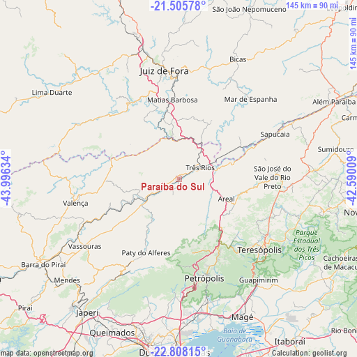
Paraíba do Sul GPS coordinates[2]
22° 9' 30.492" South, 43° 17' 35.556" West
| Map corner | latitude | longitude |
|---|---|---|
| Upper-left | -21.50578°, | -43.99634° |
| Center: | -22.15847°, | -43.29321° |
| Lower-right: | -22.80815°, | -42.59009° |
| Map W x H: | 144.8×144.8 km | = 90×90mi |
| max Lat: | 2.81972° ⇑70.9% North |
| Paraíba do Sul: | -22.15847° |
| min Lat: | ⇓29.1% South -33.69111° |
| min Long | Paraíba do Sul | max Long |
| -72.89583° | -43.29321° | -32.41083° |
| W 59%⇐ | ⇒41% E |
Elevation
Elevation of Paraíba do Sul is 323 m = 1060 ft, and this is 57.9 m = 190 ft below average elevation for this country.
| Max E: |
1603 m = 5259 ft | 52.1% |
| Avg. | 380.9 m = 1250 ft | |
| Paraíba do Sul | 323 m = 1060 ft | |
Min E: |
0 m = 0 ft | 47.9% |
See also: Brazil elevation on elevation.city.
Geographical zone
Paraíba do Sul is located in South Torrid zone (between Equator and Tropic of Capricorn). Distance of this Southern Tropic circle is 142.1 km =88.3 mi to South.| Distance of | km | miles | from Paraíba do Sul |
|---|---|---|---|
| Equator | 2463.8 | 1530.9 | to North |
| Tropic Capricorn | 142.1 | 88.3 | to South |
| Antarctic Circle | 4937.4 | 3068 | to South |
| South Pole | 7543.3 | 4687.2 | to South |


Nearby cities:
15 places around Paraíba do Sul: (largest is in red/bold)
• Areal
20.9 km =13 mi,  112°
112°
• Bicas
53.9 km =33.5 mi,  26°
26°
• Guapimirim
52.9 km =32.9 mi,  142°
142°
• Juiz de Fora
44.2 km =27.5 mi,  352°
352°
• Mar de Espanha
43.6 km =27.1 mi,  42°
42°
• Matias Barbosa
32.3 km =20.1 mi,  355°
355°
• Miguel Pereira
37.5 km =23.3 mi,  208°
208°
• Paty do Alferes
32.7 km =20.3 mi,  203°
203°
• Petrópolis
40.3 km =25 mi,  162°
162°
• Sapucaia
43.1 km =26.8 mi,  65°
65°
• São Pedro
44.7 km =27.8 mi,  131°
131°
• Teresópolis
43.3 km =26.9 mi, 131°
• Três Rios
9.8 km =6.1 mi,  61°
61°
• Valença
43 km =26.7 mi,  256°
256°
• Vassouras
46.8 km =29.1 mi,  234°
234°
Sources, notices
• [Note1] Compared only with cities in Brazil existing in our database
• [Src1] Map data: © OpenStreetMap contributors (CC-BY-SA)
• [Src2] Other city data from geonames.org with taken over terms of usage.
• [Src3] Geographical zone / Annual Mean Temperature by Robert A. Rohde @ Wikipedia
