Juiz de Fora geodata
Juiz de Fora (Minas Gerais) is a seat of a second-order administrative division; located in Brazil in America/Sao_Paulo (GMT-3) time zone. With population of 470,193 people, there are 37 cities with bigger population in this country. Compared to other cities in Brazil, 68.5% of cities are located further ↑North; 58.8% of cities are located further ←West and 81.2% of cities have lower elevation than Juiz de Fora. Note1


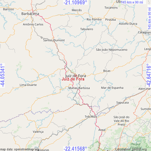
Juiz de Fora GPS coordinates[2]
21° 45' 51.012" South, 43° 21' 1.008" West
| Map corner | latitude | longitude |
|---|---|---|
| Upper-left | -21.10969°, | -44.05341° |
| Center: | -21.76417°, | -43.35028° |
| Lower-right: | -22.41568°, | -42.64716° |
| Map W x H: | 145.2×145.2 km | = 90.2×90.2mi |
| max Lat: | 2.81972° ⇑68.5% North |
| Juiz de Fora: | -21.76417° |
| min Lat: | ⇓31.5% South -33.69111° |
| min Long | Juiz de Fora | max Long |
| -72.89583° | -43.35028° | -32.41083° |
| W 58.8%⇐ | ⇒41.2% E |
Elevation
Elevation of Juiz de Fora is 707 m = 2320 ft, and this is 326.1 m = 1070 ft above average elevation for this country.
| Max E: |
1603 m = 5259 ft | 18.8% |
| Juiz de Fora | 707 m 2320 ft | |
| Avg. | 380.9 m = 1250 ft | |
Min E: |
0 m = 0 ft | 81.2% |
See also: Juiz de Fora elevation on elevation.city.
Geographical zone
Juiz de Fora is located in South Torrid zone (between Equator and Tropic of Capricorn). Distance of this Southern Tropic circle is 186 km =115.6 mi to South.| Distance of | km | miles | from Juiz de Fora |
|---|---|---|---|
| Equator | 2419.9 | 1503.7 | to North |
| Tropic Capricorn | 186 | 115.6 | to South |
| Antarctic Circle | 4981.2 | 3095.2 | to South |
| South Pole | 7587.1 | 4714.4 | to South |


Nearby cities:
15 places around Juiz de Fora: (largest is in red/bold)
• Além Paraíba
68.1 km =42.3 mi,  101°
101°
• Areal
57.7 km =35.9 mi,  154°
154°
• Astolfo Dutra
71 km =44.1 mi,  45°
45°
• Bicas
30.3 km =18.8 mi,  81°
81°
• Lima Duarte
46.5 km =28.9 mi,  259°
259°
• Mar de Espanha
37 km =23 mi,  108°
108°
• Matias Barbosa
12.1 km =7.5 mi,  164°
164°
• Paraíba do Sul
44.2 km =27.5 mi,  172°
172°
• Rio Novo
39.5 km =24.5 mi,  35°
35°
• Rio Pomba
57.2 km =35.5 mi,  18°
18°
• Santos Dumont
40.1 km =24.9 mi,  328°
328°
• Sapucaia
51.8 km =32.2 mi,  119°
119°
• São João Nepomuceno
43.1 km =26.8 mi, 54°
• Três Rios
41.8 km =26 mi, 159°
• Valença
64.6 km =40.1 mi,  213°
213°
Sources, notices
• [Note1] Compared only with cities in Brazil existing in our database
• [Src1] Map data: © OpenStreetMap contributors (CC-BY-SA)
• [Src2] Other city data from geonames.org with taken over terms of usage.
• [Src3] Geographical zone / Annual Mean Temperature by Robert A. Rohde @ Wikipedia
