Mar de Espanha geodata
Mar de Espanha (Minas Gerais) is a populated place; located in Brazil in America/Sao_Paulo (GMT-3) time zone. With population of 9,677 people, there are 1674 cities with bigger population in this country. Compared to other cities in Brazil, 69.2% of cities are located further ↑North; 60.4% of cities are located further ←West and 61.2% of cities have lower elevation than Mar de Espanha. Note1


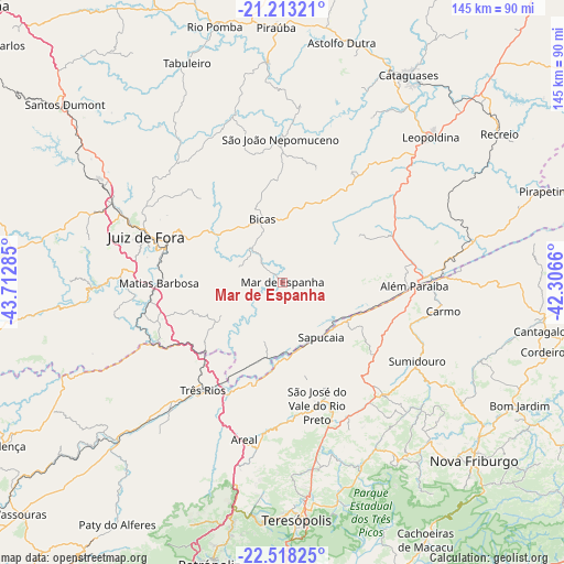
Mar de Espanha GPS coordinates[2]
21° 52' 1.992" South, 43° 0' 34.992" West
| Map corner | latitude | longitude |
|---|---|---|
| Upper-left | -21.21321°, | -43.71285° |
| Center: | -21.86722°, | -43.00972° |
| Lower-right: | -22.51825°, | -42.3066° |
| Map W x H: | 145.1×145.1 km | = 90.2×90.2mi |
| max Lat: | 2.81972° ⇑69.2% North |
| Mar de Espanha: | -21.86722° |
| min Lat: | ⇓30.8% South -33.69111° |
| min Long | Mar de Espanha | max Long |
| -72.89583° | -43.00972° | -32.41083° |
| W 60.4%⇐ | ⇒39.6% E |
Elevation
Elevation of Mar de Espanha is 484 m = 1588 ft, and this is 103.1 m = 338 ft above average elevation for this country.
| Max E: |
1603 m = 5259 ft | 38.8% |
| Mar de Espanha | 484 m 1588 ft | |
| Avg. | 380.9 m = 1250 ft | |
Min E: |
0 m = 0 ft | 61.2% |
See also: Brazil elevation on elevation.city.
Geographical zone
Mar de Espanha is located in South Torrid zone (between Equator and Tropic of Capricorn). Distance of this Southern Tropic circle is 174.5 km =108.4 mi to South.| Distance of | km | miles | from Mar de Espanha |
|---|---|---|---|
| Equator | 2431.4 | 1510.8 | to North |
| Tropic Capricorn | 174.5 | 108.4 | to South |
| Antarctic Circle | 4969.8 | 3088.1 | to South |
| South Pole | 7575.7 | 4707.3 | to South |


Nearby cities:
15 places around Mar de Espanha: (largest is in red/bold)
• Além Paraíba
31.6 km =19.6 mi,  94°
94°
• Areal
41.6 km =25.8 mi,  193°
193°
• Bicas
16.6 km =10.3 mi,  341°
341°
• Carmo
42 km =26.1 mi,  100°
100°
• Cataguases
62.2 km =38.6 mi,  31°
31°
• Juiz de Fora
37 km =23 mi,  288°
288°
• Leopoldina
53.1 km =33 mi,  45°
45°
• Matias Barbosa
32 km =19.9 mi,  269°
269°
• Paraíba do Sul
43.6 km =27.1 mi,  222°
222°
• Rio Novo
45 km =28 mi, 344°
• Sapucaia
17.3 km =10.7 mi,  145°
145°
• São João Nepomuceno
36.4 km =22.6 mi,  359°
359°
• São Pedro
62 km =38.5 mi,  175°
175°
• Teresópolis
61.2 km =38 mi, 176°
• Três Rios
34.5 km =21.4 mi, 216°
Sources, notices
• [Note1] Compared only with cities in Brazil existing in our database
• [Src1] Map data: © OpenStreetMap contributors (CC-BY-SA)
• [Src2] Other city data from geonames.org with taken over terms of usage.
• [Src3] Geographical zone / Annual Mean Temperature by Robert A. Rohde @ Wikipedia
