São Pedro geodata
São Pedro (São Paulo) is a populated place; located in Brazil in America/Sao_Paulo (GMT-3) time zone. With population of 27,068 people, there are 730 cities with bigger population in this country. Compared to other cities in Brazil, 74.3% of cities are located further ↑North; 64.1% of cities are located further →East and 69% of cities have lower elevation than São Pedro. Note1


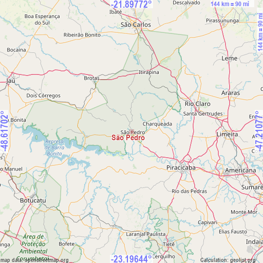
São Pedro GPS coordinates[2]
22° 32' 54.996" South, 47° 54' 50.004" West
| Map corner | latitude | longitude |
|---|---|---|
| Upper-left | -21.89772°, | -48.61702° |
| Center: | -22.54861°, | -47.91389° |
| Lower-right: | -23.19644°, | -47.21077° |
| Map W x H: | 144.4×144.4 km | = 89.7×89.7mi |
| max Lat: | 2.81972° ⇑74.3% North |
| São Pedro: | -22.54861° |
| min Lat: | ⇓25.7% South -33.69111° |
| min Long | São Pedro | max Long |
| -72.89583° | -47.91389° | -32.41083° |
| W 35.9%⇐ | ⇒64.1% E |
Elevation
Elevation of São Pedro is 566 m = 1857 ft, and this is 185.1 m = 607 ft above average elevation for this country.
| Max E: |
1603 m = 5259 ft | 31% |
| São Pedro | 566 m 1857 ft | |
| Avg. | 380.9 m = 1250 ft | |
Min E: |
0 m = 0 ft | 69% |
See also: Brazil elevation on elevation.city.
Geographical zone
São Pedro is located in South Torrid zone (between Equator and Tropic of Capricorn). Distance of this Southern Tropic circle is 98.7 km =61.3 mi to South.| Distance of | km | miles | from São Pedro |
|---|---|---|---|
| Equator | 2507.2 | 1557.9 | to North |
| Tropic Capricorn | 98.7 | 61.3 | to South |
| Antarctic Circle | 4894 | 3041 | to South |
| South Pole | 7499.9 | 4660.2 | to South |


Nearby cities:
15 places around São Pedro: (largest is in red/bold)
• Araras
58.5 km =36.4 mi,  68°
68°
• Brotas
36.6 km =22.7 mi,  323°
323°
• Charqueada
14.6 km =9.1 mi, 72°
• Conchas
52.8 km =32.8 mi,  190°
190°
• Cordeirópolis
47.5 km =29.5 mi,  81°
81°
• Dois Córregos
52 km =32.3 mi,  292°
292°
• Iracemápolis
40.7 km =25.3 mi,  95°
95°
• Itirapina
34.2 km =21.3 mi,  15°
15°
• Laranjal Paulista
56.3 km =35 mi,  171°
171°
• Limeira
52.6 km =32.7 mi,  91°
91°
• Piracicaba
33.5 km =20.8 mi,  125°
125°
• Rio Claro
39.3 km =24.4 mi, 67°
• Rio das Pedras
45.5 km =28.3 mi,  136°
136°
• Santa Bárbara d'Oeste
56.2 km =34.9 mi,  113°
113°
• Santa Gertrudes
40.7 km =25.3 mi, 75°
Sources, notices
• [Note1] Compared only with cities in Brazil existing in our database
• [Src1] Map data: © OpenStreetMap contributors (CC-BY-SA)
• [Src2] Other city data from geonames.org with taken over terms of usage.
• [Src3] Geographical zone / Annual Mean Temperature by Robert A. Rohde @ Wikipedia
