Brotas geodata
Brotas (São Paulo) is a populated place; located in Brazil in America/Sao_Paulo (GMT-3) time zone. With population of 18,689 people, there are 1000 cities with bigger population in this country. Compared to other cities in Brazil, 71.8% of cities are located further ↑North; 65.2% of cities are located further →East and 76.9% of cities have lower elevation than Brotas. Note1


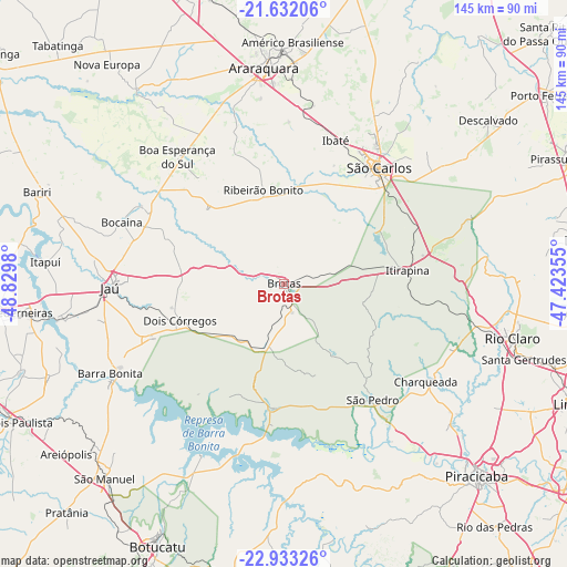
Brotas GPS coordinates[2]
22° 17' 3.012" South, 48° 7' 36.012" West
| Map corner | latitude | longitude |
|---|---|---|
| Upper-left | -21.63206°, | -48.8298° |
| Center: | -22.28417°, | -48.12667° |
| Lower-right: | -22.93326°, | -47.42355° |
| Map W x H: | 144.7×144.7 km | = 89.9×89.9mi |
| max Lat: | 2.81972° ⇑71.8% North |
| Brotas: | -22.28417° |
| min Lat: | ⇓28.2% South -33.69111° |
| min Long | Brotas | max Long |
| -72.89583° | -48.12667° | -32.41083° |
| W 34.8%⇐ | ⇒65.2% E |
Elevation
Elevation of Brotas is 651 m = 2136 ft, and this is 270.1 m = 886 ft above average elevation for this country.
| Max E: |
1603 m = 5259 ft | 23.1% |
| Brotas | 651 m 2136 ft | |
| Avg. | 380.9 m = 1250 ft | |
Min E: |
0 m = 0 ft | 76.9% |
See also: Brazil elevation on elevation.city.
Geographical zone
Brotas is located in South Torrid zone (between Equator and Tropic of Capricorn). Distance of this Southern Tropic circle is 128.2 km =79.7 mi to South.| Distance of | km | miles | from Brotas |
|---|---|---|---|
| Equator | 2477.8 | 1539.6 | to North |
| Tropic Capricorn | 128.2 | 79.7 | to South |
| Antarctic Circle | 4923.4 | 3059.3 | to South |
| South Pole | 7529.3 | 4678.5 | to South |


Nearby cities:
15 places around Brotas: (largest is in red/bold)
• Américo Brasiliense
62.3 km =38.7 mi,  2°
2°
• Araraquara
54.7 km =34 mi,  354°
354°
• Barra Bonita
50.1 km =31.1 mi,  242°
242°
• Boa Esperança do Sul
42.3 km =26.3 mi,  320°
320°
• Charqueada
43.7 km =27.2 mi,  124°
124°
• Dois Córregos
27.6 km =17.1 mi,  250°
250°
• Ibaté
39 km =24.2 mi,  20°
20°
• Igaraçu do Tietê
50.9 km =31.6 mi, 240°
• Itapuí
61.2 km =38 mi,  275°
275°
• Itirapina
31.5 km =19.6 mi,  83°
83°
• Jaú
44.4 km =27.6 mi,  268°
268°
• Ribeirão Bonito
24.7 km =15.3 mi, 348°
• Rio Claro
59.8 km =37.2 mi,  103°
103°
• São Carlos
38.3 km =23.8 mi,  39°
39°
• São Pedro
36.6 km =22.7 mi,  143°
143°
Sources, notices
• [Note1] Compared only with cities in Brazil existing in our database
• [Src1] Map data: © OpenStreetMap contributors (CC-BY-SA)
• [Src2] Other city data from geonames.org with taken over terms of usage.
• [Src3] Geographical zone / Annual Mean Temperature by Robert A. Rohde @ Wikipedia
