Conchas geodata
Conchas (São Paulo) is a populated place; located in Brazil in America/Sao_Paulo (GMT-3) time zone. With population of 14,301 people, there are 1266 cities with bigger population in this country. Compared to other cities in Brazil, 78.7% of cities are located further ↑North; 64.6% of cities are located further →East and 62.9% of cities have lower elevation than Conchas. Note1


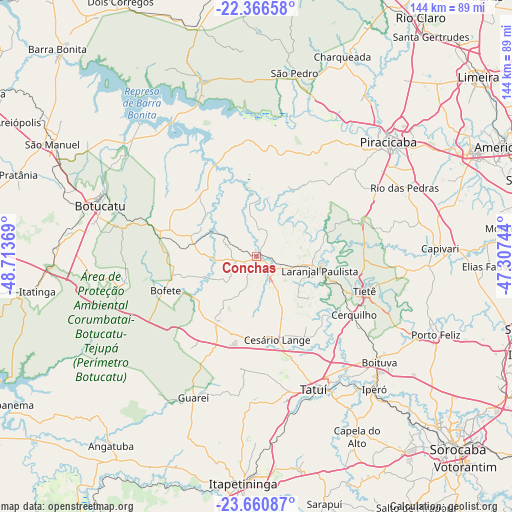
Conchas GPS coordinates[2]
23° 0' 55.008" South, 48° 0' 38.016" West
| Map corner | latitude | longitude |
|---|---|---|
| Upper-left | -22.36658°, | -48.71369° |
| Center: | -23.01528°, | -48.01056° |
| Lower-right: | -23.66087°, | -47.30744° |
| Map W x H: | 143.9×143.9 km | = 89.4×89.4mi |
| max Lat: | 2.81972° ⇑78.7% North |
| Conchas: | -23.01528° |
| min Lat: | ⇓21.3% South -33.69111° |
| min Long | Conchas | max Long |
| -72.89583° | -48.01056° | -32.41083° |
| W 35.4%⇐ | ⇒64.6% E |
Elevation
Elevation of Conchas is 508 m = 1667 ft, and this is 127.1 m = 417 ft above average elevation for this country.
| Max E: |
1603 m = 5259 ft | 37.1% |
| Conchas | 508 m 1667 ft | |
| Avg. | 380.9 m = 1250 ft | |
Min E: |
0 m = 0 ft | 62.9% |
See also: Brazil elevation on elevation.city.
Geographical zone
Conchas is located in South Torrid zone (between Equator and Tropic of Capricorn). Distance of this Southern Tropic circle is 46.9 km =29.1 mi to South.| Distance of | km | miles | from Conchas |
|---|---|---|---|
| Equator | 2559.1 | 1590.2 | to North |
| Tropic Capricorn | 46.9 | 29.1 | to South |
| Antarctic Circle | 4842.1 | 3008.7 | to South |
| South Pole | 7448 | 4628 | to South |


Nearby cities:
15 places around Conchas: (largest is in red/bold)
• Boituva
45.7 km =28.4 mi,  130°
130°
• Botucatu
46.8 km =29.1 mi,  287°
287°
• Capela do Alto
57.9 km =36 mi,  150°
150°
• Capivari
51.5 km =32 mi,  87°
87°
• Cerquilho
32 km =19.9 mi,  121°
121°
• Charqueada
61.1 km =38 mi,  22°
22°
• Iperó
49.7 km =30.9 mi,  138°
138°
• Laranjal Paulista
18.2 km =11.3 mi,  102°
102°
• Piracicaba
49.1 km =30.5 mi,  48°
48°
• Porangaba
21.3 km =13.2 mi,  213°
213°
• Porto Feliz
54.5 km =33.9 mi,  114°
114°
• Rio das Pedras
45.6 km =28.3 mi,  65°
65°
• São Pedro
52.8 km =32.8 mi,  10°
10°
• Tatuí
41 km =25.5 mi,  157°
157°
• Tietê
31.8 km =19.8 mi, 107°
Sources, notices
• [Note1] Compared only with cities in Brazil existing in our database
• [Src1] Map data: © OpenStreetMap contributors (CC-BY-SA)
• [Src2] Other city data from geonames.org with taken over terms of usage.
• [Src3] Geographical zone / Annual Mean Temperature by Robert A. Rohde @ Wikipedia
