São Paulo geodata
São Paulo is a seat of a first-order administrative division; located in Brazil in America/Sao_Paulo (GMT-3) time zone. With population of 10,021,295 people, there are 0 cities with bigger population in this country. Compared to other cities in Brazil, 83.3% of cities are located further ↑North; 56% of cities are located further →East and 86.3% of cities have lower elevation than São Paulo. Note1


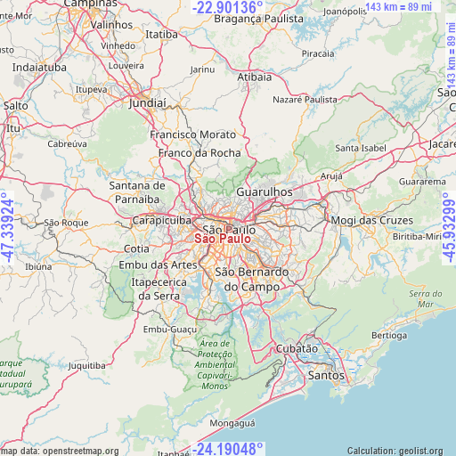
São Paulo GPS coordinates[2]
23° 32' 51" South, 46° 38' 9.996" West
| Map corner | latitude | longitude |
|---|---|---|
| Upper-left | -22.90136°, | -47.33924° |
| Center: | -23.5475°, | -46.63611° |
| Lower-right: | -24.19048°, | -45.93299° |
| Map W x H: | 143.3×143.3 km | = 89×89mi |
| max Lat: | 2.81972° ⇑83.3% North |
| São Paulo: | -23.5475° |
| min Lat: | ⇓16.7% South -33.69111° |
| min Long | São Paulo | max Long |
| -72.89583° | -46.63611° | -32.41083° |
| W 44%⇐ | ⇒56% E |
Elevation
Elevation of São Paulo is 769 m = 2523 ft, and this is 388.1 m = 1273 ft above average elevation for this country.
| Max E: |
1603 m = 5259 ft | 13.7% |
| São Paulo | 769 m 2523 ft | |
| Avg. | 380.9 m = 1250 ft | |
Min E: |
0 m = 0 ft | 86.3% |
See also: São Paulo elevation on elevation.city.
Geographical zone
São Paulo is located in South temperate zone (between Tropic of Capricorn and the Antarctic Circle). Distance of this Southern Tropic circle is 12.3 km =7.6 mi to North.| Distance of | km | miles | from São Paulo |
|---|---|---|---|
| Equator | 2618.2 | 1626.9 | to North |
| Tropic Capricorn | 12.3 | 7.6 | to North |
| Antarctic Circle | 4782.9 | 2972 | to South |
| South Pole | 7388.8 | 4591.2 | to South |


Nearby cities:
15 places around São Paulo: (largest is in red/bold)
• Barueri
24.8 km =15.4 mi,  279°
279°
• Caieiras
23 km =14.3 mi,  332°
332°
• Carapicuíba
20.5 km =12.7 mi, 277°
• Diadema
15.5 km =9.6 mi,  174°
174°
• Embu
24.7 km =15.3 mi,  242°
242°
• Guarulhos
14.1 km =8.8 mi,  48°
48°
• Jardim Paulista
3.6 km =2.2 mi,  233°
233°
• Mairiporã
25.9 km =16.1 mi,  11°
11°
• Mauá
22.3 km =13.9 mi,  126°
126°
• Osasco
15.9 km =9.9 mi, 276°
• Paraíso
3.5 km =2.2 mi,  205°
205°
• Santo André
16.3 km =10.1 mi,  142°
142°
• São Bernardo do Campo
17.8 km =11.1 mi,  156°
156°
• São Caetano do Sul
12.1 km =7.5 mi, 134°
• Taboão da Serra
18.1 km =11.2 mi, 241°
Sources, notices
• [Note1] Compared only with cities in Brazil existing in our database
• [Src1] Map data: © OpenStreetMap contributors (CC-BY-SA)
• [Src2] Other city data from geonames.org with taken over terms of usage.
• [Src3] Geographical zone / Annual Mean Temperature by Robert A. Rohde @ Wikipedia
