Taboão da Serra geodata
Taboão da Serra (São Paulo) is a seat of a second-order administrative division; located in Brazil in America/Sao_Paulo (GMT-3) time zone. With population of 214,523 people, there are 105 cities with bigger population in this country. Compared to other cities in Brazil, 83.9% of cities are located further ↑North; 56.9% of cities are located further →East and 88.9% of cities have lower elevation than Taboão da Serra. Note1


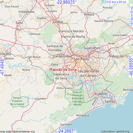
Taboão da Serra GPS coordinates[2]
23° 37' 33.996" South, 46° 47' 30.012" West
| Map corner | latitude | longitude |
|---|---|---|
| Upper-left | -22.98035°, | -47.4948° |
| Center: | -23.62611°, | -46.79167° |
| Lower-right: | -24.2687°, | -46.08855° |
| Map W x H: | 143.3×143.3 km | = 89×89mi |
| max Lat: | 2.81972° ⇑83.9% North |
| Taboão da Serra: | -23.62611° |
| min Lat: | ⇓16.1% South -33.69111° |
| min Long | Taboão da Serr | max Long |
| -72.89583° | -46.79167° | -32.41083° |
| W 43.1%⇐ | ⇒56.9% E |
Elevation
Elevation of Taboão da Serra is 795 m = 2608 ft, and this is 414.1 m = 1359 ft above average elevation for this country.
| Max E: |
1603 m = 5259 ft | 11.1% |
| Taboão da Serra | 795 m 2608 ft | |
| Avg. | 380.9 m = 1250 ft | |
Min E: |
0 m = 0 ft | 88.9% |
See also: Taboão da Serra elevation on elevation.city.
Geographical zone
Taboão da Serra is located in South temperate zone (between Tropic of Capricorn and the Antarctic Circle). Distance of this Southern Tropic circle is 21.1 km =13.1 mi to North.| Distance of | km | miles | from Taboão da Serra |
|---|---|---|---|
| Equator | 2627 | 1632.3 | to North |
| Tropic Capricorn | 21.1 | 13.1 | to North |
| Antarctic Circle | 4774.2 | 2966.5 | to South |
| South Pole | 7380.1 | 4585.8 | to South |


Nearby cities:
15 places around Taboão da Serra: (largest is in red/bold)
• Barueri
15.5 km =9.6 mi,  326°
326°
• Carapicuíba
12.3 km =7.6 mi,  338°
338°
• Cotia
13.2 km =8.2 mi,  280°
280°
• Diadema
18.4 km =11.4 mi,  111°
111°
• Embu
6.7 km =4.2 mi,  247°
247°
• Embu Guaçu
23 km =14.3 mi,  185°
185°
• Itapecerica da Serra
11.7 km =7.3 mi,  210°
210°
• Itapevi
16.9 km =10.5 mi,  300°
300°
• Jandira
15.7 km =9.8 mi,  314°
314°
• Jardim Paulista
14.6 km =9.1 mi,  63°
63°
• Osasco
10.4 km =6.5 mi,  0°
0°
• Paraíso
15.4 km =9.6 mi,  68°
68°
• Santana de Parnaíba
24 km =14.9 mi, 327°
• São Paulo
18.1 km =11.2 mi, 61°
• Vargem Grande Paulista
24 km =14.9 mi, 276°
Sources, notices
• [Note1] Compared only with cities in Brazil existing in our database
• [Src1] Map data: © OpenStreetMap contributors (CC-BY-SA)
• [Src2] Other city data from geonames.org with taken over terms of usage.
• [Src3] Geographical zone / Annual Mean Temperature by Robert A. Rohde @ Wikipedia
