Diadema geodata
Diadema (São Paulo) is a populated place; located in Brazil in America/Sao_Paulo (GMT-3) time zone. With population of 390,633 people, there are 48 cities with bigger population in this country. Compared to other cities in Brazil, 84.3% of cities are located further ↑North; 55.8% of cities are located further →East and 87.9% of cities have lower elevation than Diadema. Note1


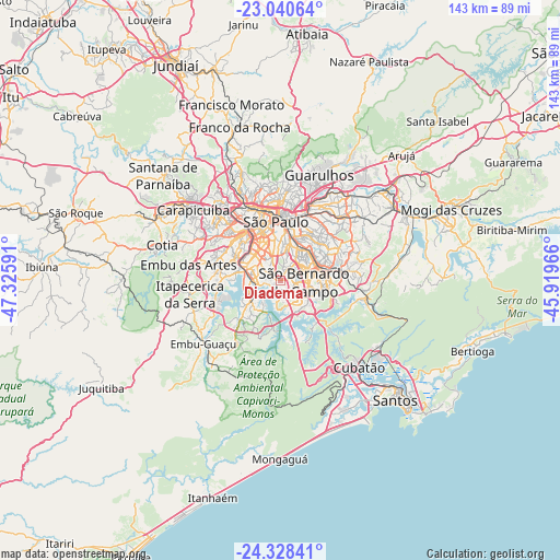
Diadema GPS coordinates[2]
23° 41' 9.996" South, 46° 37' 22.008" West
| Map corner | latitude | longitude |
|---|---|---|
| Upper-left | -23.04064°, | -47.32591° |
| Center: | -23.68611°, | -46.62278° |
| Lower-right: | -24.32841°, | -45.91966° |
| Map W x H: | 143.2×143.2 km | = 89×89mi |
| max Lat: | 2.81972° ⇑84.3% North |
| Diadema: | -23.68611° |
| min Lat: | ⇓15.7% South -33.69111° |
| min Long | Diadema | max Long |
| -72.89583° | -46.62278° | -32.41083° |
| W 44.2%⇐ | ⇒55.8% E |
Elevation
Elevation of Diadema is 784 m = 2572 ft, and this is 403.1 m = 1323 ft above average elevation for this country.
| Max E: |
1603 m = 5259 ft | 12.1% |
| Diadema | 784 m 2572 ft | |
| Avg. | 380.9 m = 1250 ft | |
Min E: |
0 m = 0 ft | 87.9% |
See also: Diadema elevation on elevation.city.
Geographical zone
Diadema is located in South temperate zone (between Tropic of Capricorn and the Antarctic Circle). Distance of this Southern Tropic circle is 27.7 km =17.2 mi to North.| Distance of | km | miles | from Diadema |
|---|---|---|---|
| Equator | 2633.6 | 1636.4 | to North |
| Tropic Capricorn | 27.7 | 17.2 | to North |
| Antarctic Circle | 4767.5 | 2962.4 | to South |
| South Pole | 7373.4 | 4581.6 | to South |


Nearby cities:
15 places around Diadema: (largest is in red/bold)
• Embu
23.7 km =14.7 mi,  280°
280°
• Embu Guaçu
25.1 km =15.6 mi,  229°
229°
• Guarulhos
26.5 km =16.5 mi,  20°
20°
• Itapecerica da Serra
23.3 km =14.5 mi,  261°
261°
• Jardim Paulista
13.9 km =8.6 mi,  342°
342°
• Mauá
16.6 km =10.3 mi,  82°
82°
• Osasco
24.2 km =15 mi,  314°
314°
• Paraíso
12.6 km =7.8 mi,  346°
346°
• Ribeirão Pires
21.5 km =13.4 mi,  97°
97°
• Rio Grande da Serra
23.7 km =14.7 mi,  105°
105°
• Santo André
8.9 km =5.5 mi,  73°
73°
• São Bernardo do Campo
5.9 km =3.7 mi, 98°
• São Caetano do Sul
10.1 km =6.3 mi,  46°
46°
• São Paulo
15.5 km =9.6 mi, 354°
• Taboão da Serra
18.4 km =11.4 mi,  291°
291°
Sources, notices
• [Note1] Compared only with cities in Brazil existing in our database
• [Src1] Map data: © OpenStreetMap contributors (CC-BY-SA)
• [Src2] Other city data from geonames.org with taken over terms of usage.
• [Src3] Geographical zone / Annual Mean Temperature by Robert A. Rohde @ Wikipedia
