Embu geodata
Embu (São Paulo) is a populated place; located in Brazil in America/Sao_Paulo (GMT-3) time zone. With population of 221,733 people, there are 102 cities with bigger population in this country. Compared to other cities in Brazil, 84% of cities are located further ↑North; 57.3% of cities are located further →East and 87.9% of cities have lower elevation than Embu. Note1


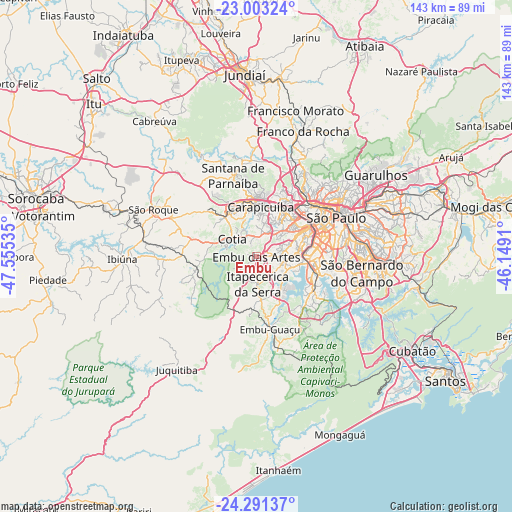
Embu GPS coordinates[2]
23° 38' 56.004" South, 46° 51' 7.992" West
| Map corner | latitude | longitude |
|---|---|---|
| Upper-left | -23.00324°, | -47.55535° |
| Center: | -23.64889°, | -46.85222° |
| Lower-right: | -24.29137°, | -46.1491° |
| Map W x H: | 143.2×143.2 km | = 89×89mi |
| max Lat: | 2.81972° ⇑84% North |
| Embu: | -23.64889° |
| min Lat: | ⇓16% South -33.69111° |
| min Long | Embu | max Long |
| -72.89583° | -46.85222° | -32.41083° |
| W 42.7%⇐ | ⇒57.3% E |
Elevation
Elevation of Embu is 784 m = 2572 ft, and this is 403.1 m = 1323 ft above average elevation for this country.
| Max E: |
1603 m = 5259 ft | 12.1% |
| Embu | 784 m 2572 ft | |
| Avg. | 380.9 m = 1250 ft | |
Min E: |
0 m = 0 ft | 87.9% |
See also: Embu elevation on elevation.city.
Geographical zone
Embu is located in South temperate zone (between Tropic of Capricorn and the Antarctic Circle). Distance of this Southern Tropic circle is 23.6 km =14.7 mi to North.| Distance of | km | miles | from Embu |
|---|---|---|---|
| Equator | 2629.5 | 1633.9 | to North |
| Tropic Capricorn | 23.6 | 14.7 | to North |
| Antarctic Circle | 4771.7 | 2965 | to South |
| South Pole | 7377.6 | 4584.2 | to South |


Nearby cities:
15 places around Embu: (largest is in red/bold)
• Barueri
15.6 km =9.7 mi,  351°
351°
• Carapicuíba
14.1 km =8.8 mi,  7°
7°
• Cotia
8.5 km =5.3 mi,  306°
306°
• Diadema
23.7 km =14.7 mi,  100°
100°
• Embu Guaçu
20.8 km =12.9 mi,  168°
168°
• Itapecerica da Serra
7.6 km =4.7 mi,  177°
177°
• Itapevi
13.9 km =8.6 mi,  323°
323°
• Jandira
14.4 km =8.9 mi,  339°
339°
• Jardim Paulista
21.2 km =13.2 mi,  64°
64°
• Osasco
14.3 km =8.9 mi,  25°
25°
• Paraíso
22.1 km =13.7 mi,  68°
68°
• Santana de Parnaíba
23.7 km =14.7 mi, 343°
• São Lourenço da Serra
24.4 km =15.2 mi,  202°
202°
• Taboão da Serra
6.7 km =4.2 mi, 67°
• Vargem Grande Paulista
18.5 km =11.5 mi,  285°
285°
Sources, notices
• [Note1] Compared only with cities in Brazil existing in our database
• [Src1] Map data: © OpenStreetMap contributors (CC-BY-SA)
• [Src2] Other city data from geonames.org with taken over terms of usage.
• [Src3] Geographical zone / Annual Mean Temperature by Robert A. Rohde @ Wikipedia
