São Lourenço geodata
São Lourenço (Minas Gerais) is a populated place; located in Brazil in America/Sao_Paulo (GMT-3) time zone. With population of 41,143 people, there are 514 cities with bigger population in this country. Compared to other cities in Brazil, 70.7% of cities are located further ↑North; 51.1% of cities are located further ←West and 94.2% of cities have lower elevation than São Lourenço. Note1


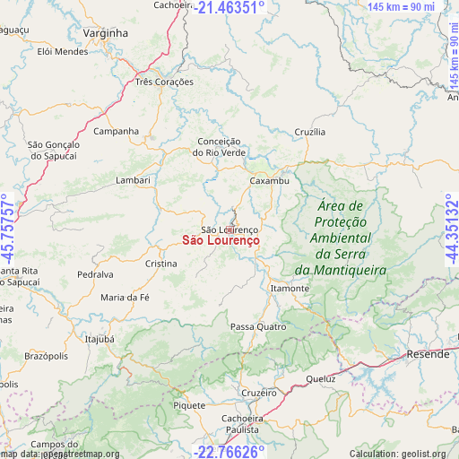
São Lourenço GPS coordinates[2]
22° 6' 59.004" South, 45° 3' 15.984" West
| Map corner | latitude | longitude |
|---|---|---|
| Upper-left | -21.46351°, | -45.75757° |
| Center: | -22.11639°, | -45.05444° |
| Lower-right: | -22.76626°, | -44.35132° |
| Map W x H: | 144.9×144.9 km | = 90×90mi |
| max Lat: | 2.81972° ⇑70.7% North |
| São Lourenço: | -22.11639° |
| min Lat: | ⇓29.3% South -33.69111° |
| min Long | São Lourenço | max Long |
| -72.89583° | -45.05444° | -32.41083° |
| W 51.1%⇐ | ⇒48.9% E |
Elevation
Elevation of São Lourenço is 884 m = 2900 ft, and this is 503.1 m = 1651 ft above average elevation for this country.
| Max E: |
1603 m = 5259 ft | 5.8% |
| São Lourenço | 884 m 2900 ft | |
| Avg. | 380.9 m = 1250 ft | |
Min E: |
0 m = 0 ft | 94.2% |
See also: São Lourenço elevation on elevation.city.
Geographical zone
São Lourenço is located in South Torrid zone (between Equator and Tropic of Capricorn). Distance of this Southern Tropic circle is 146.8 km =91.2 mi to South.| Distance of | km | miles | from São Lourenço |
|---|---|---|---|
| Equator | 2459.1 | 1528 | to North |
| Tropic Capricorn | 146.8 | 91.2 | to South |
| Antarctic Circle | 4942.1 | 3070.9 | to South |
| South Pole | 7547.9 | 4690 | to South |


Nearby cities:
15 places around São Lourenço: (largest is in red/bold)
• Baependi
24.4 km =15.2 mi,  44°
44°
• Cambuquira
38.5 km =23.9 mi,  319°
319°
• Campanha
47.4 km =29.5 mi,  311°
311°
• Caxambu
19.9 km =12.4 mi, 39°
• Conceição do Rio Verde
26.4 km =16.4 mi,  353°
353°
• Cruzeiro
51.5 km =32 mi,  170°
170°
• Cruzília
40 km =24.9 mi, 39°
• Itajubá
53.5 km =33.2 mi,  230°
230°
• Itanhandu
23.5 km =14.6 mi,  148°
148°
• Itatiaia
65.8 km =40.9 mi,  129°
129°
• Lambari
34.3 km =21.3 mi,  297°
297°
• Passa Quatro
31.8 km =19.8 mi,  163°
163°
• Piquete
56.7 km =35.2 mi,  192°
192°
• São Gonçalo do Sapucaí
61.1 km =38 mi,  294°
294°
• Três Corações
51 km =31.7 mi,  336°
336°
Sources, notices
• [Note1] Compared only with cities in Brazil existing in our database
• [Src1] Map data: © OpenStreetMap contributors (CC-BY-SA)
• [Src2] Other city data from geonames.org with taken over terms of usage.
• [Src3] Geographical zone / Annual Mean Temperature by Robert A. Rohde @ Wikipedia
