Itatiaia geodata
Itatiaia (Rio de Janeiro) is a populated place; located in Brazil in America/Sao_Paulo (GMT-3) time zone. With population of 12,571 people, there are 1416 cities with bigger population in this country. Compared to other cities in Brazil, 73.7% of cities are located further ↑North; 53.2% of cities are located further ←West and 53.7% of cities have lower elevation than Itatiaia. Note1


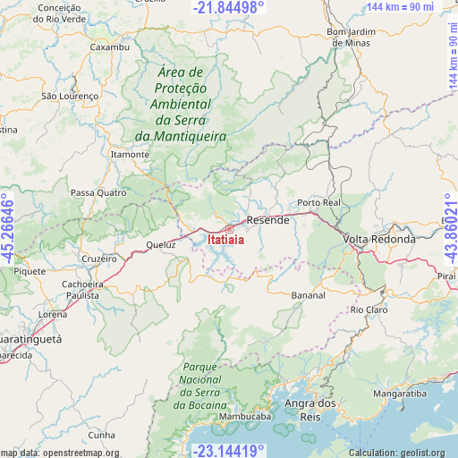
Itatiaia GPS coordinates[2]
22° 29' 45.996" South, 44° 33' 47.988" West
| Map corner | latitude | longitude |
|---|---|---|
| Upper-left | -21.84498°, | -45.26646° |
| Center: | -22.49611°, | -44.56333° |
| Lower-right: | -23.14419°, | -43.86021° |
| Map W x H: | 144.5×144.5 km | = 89.8×89.8mi |
| max Lat: | 2.81972° ⇑73.7% North |
| Itatiaia: | -22.49611° |
| min Lat: | ⇓26.3% South -33.69111° |
| min Long | Itatiaia | max Long |
| -72.89583° | -44.56333° | -32.41083° |
| W 53.2%⇐ | ⇒46.8% E |
Elevation
Elevation of Itatiaia is 406 m = 1332 ft, and this is 25.1 m = 82 ft above average elevation for this country.
| Max E: |
1603 m = 5259 ft | 46.3% |
| Itatiaia | 406 m 1332 ft | |
| Avg. | 380.9 m = 1250 ft | |
Min E: |
0 m = 0 ft | 53.7% |
See also: Brazil elevation on elevation.city.
Geographical zone
Itatiaia is located in South Torrid zone (between Equator and Tropic of Capricorn). Distance of this Southern Tropic circle is 104.6 km =65 mi to South.| Distance of | km | miles | from Itatiaia |
|---|---|---|---|
| Equator | 2501.3 | 1554.2 | to North |
| Tropic Capricorn | 104.6 | 65 | to South |
| Antarctic Circle | 4899.8 | 3044.6 | to South |
| South Pole | 7505.7 | 4663.8 | to South |


Nearby cities:
15 places around Itatiaia: (largest is in red/bold)
• Angra dos Reis
62.1 km =38.6 mi,  156°
156°
• Baependi
68.5 km =42.6 mi,  330°
330°
• Barra Mansa
40.6 km =25.2 mi,  97°
97°
• Cruzeiro
42.7 km =26.5 mi,  258°
258°
• Itanhandu
44.2 km =27.5 mi,  300°
300°
• Lorena
63.3 km =39.3 mi,  245°
245°
• Passa Quatro
43.1 km =26.8 mi,  285°
285°
• Pinheiral
57.8 km =35.9 mi,  91°
91°
• Piquete
64.3 km =40 mi, 258°
• Porto Real
29.3 km =18.2 mi,  73°
73°
• Quatis
32.9 km =20.4 mi, 72°
• Resende
12.4 km =7.7 mi,  75°
75°
• Rio Claro
50.6 km =31.4 mi,  119°
119°
• São Lourenço
65.8 km =40.9 mi,  309°
309°
• Volta Redonda
47.3 km =29.4 mi, 93°
Sources, notices
• [Note1] Compared only with cities in Brazil existing in our database
• [Src1] Map data: © OpenStreetMap contributors (CC-BY-SA)
• [Src2] Other city data from geonames.org with taken over terms of usage.
• [Src3] Geographical zone / Annual Mean Temperature by Robert A. Rohde @ Wikipedia
