Itajubá geodata
Itajubá (Minas Gerais) is a populated place; located in Brazil in America/Sao_Paulo (GMT-3) time zone. With population of 81,870 people, there are 281 cities with bigger population in this country. Compared to other cities in Brazil, 72.9% of cities are located further ↑North; 50.9% of cities are located further →East and 92.9% of cities have lower elevation than Itajubá. Note1


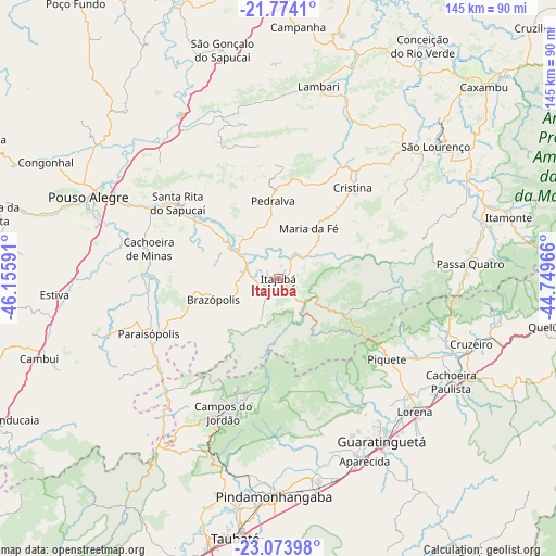
Itajubá GPS coordinates[2]
22° 25' 32.016" South, 45° 27' 10.008" West
| Map corner | latitude | longitude |
|---|---|---|
| Upper-left | -21.7741°, | -46.15591° |
| Center: | -22.42556°, | -45.45278° |
| Lower-right: | -23.07398°, | -44.74966° |
| Map W x H: | 144.5×144.5 km | = 89.8×89.8mi |
| max Lat: | 2.81972° ⇑72.9% North |
| Itajubá: | -22.42556° |
| min Lat: | ⇓27.1% South -33.69111° |
| min Long | Itajubá | max Long |
| -72.89583° | -45.45278° | -32.41083° |
| W 49.1%⇐ | ⇒50.9% E |
Elevation
Elevation of Itajubá is 858 m = 2815 ft, and this is 477.1 m = 1565 ft above average elevation for this country.
| Max E: |
1603 m = 5259 ft | 7.1% |
| Itajubá | 858 m 2815 ft | |
| Avg. | 380.9 m = 1250 ft | |
Min E: |
0 m = 0 ft | 92.9% |
See also: Itajubá elevation on elevation.city.
Geographical zone
Itajubá is located in South Torrid zone (between Equator and Tropic of Capricorn). Distance of this Southern Tropic circle is 112.4 km =69.8 mi to South.| Distance of | km | miles | from Itajubá |
|---|---|---|---|
| Equator | 2493.5 | 1549.4 | to North |
| Tropic Capricorn | 112.4 | 69.8 | to South |
| Antarctic Circle | 4907.7 | 3049.5 | to South |
| South Pole | 7513.6 | 4668.7 | to South |


Nearby cities:
15 places around Itajubá: (largest is in red/bold)
• Aparecida
52.1 km =32.4 mi,  153°
153°
• Campos do Jordão
37.7 km =23.4 mi,  202°
202°
• Cruzeiro
52.1 km =32.4 mi,  108°
108°
• Guaratinguetá
51 km =31.7 mi, 148°
• Itanhandu
55.2 km =34.3 mi,  74°
74°
• Lambari
51.1 km =31.8 mi,  11°
11°
• Lorena
47.8 km =29.7 mi,  135°
135°
• Paraisópolis
36.5 km =22.7 mi,  246°
246°
• Passa Quatro
50.1 km =31.1 mi,  85°
85°
• Pindamonhangaba
55.4 km =34.4 mi,  180°
180°
• Piquete
35.3 km =21.9 mi,  126°
126°
• Pouso Alegre
54.3 km =33.7 mi,  293°
293°
• Santa Rita do Sapucaí
32.2 km =20 mi,  306°
306°
• São Lourenço
53.5 km =33.2 mi,  50°
50°
• Tremembé
60.1 km =37.3 mi,  189°
189°
Sources, notices
• [Note1] Compared only with cities in Brazil existing in our database
• [Src1] Map data: © OpenStreetMap contributors (CC-BY-SA)
• [Src2] Other city data from geonames.org with taken over terms of usage.
• [Src3] Geographical zone / Annual Mean Temperature by Robert A. Rohde @ Wikipedia
