Passa Quatro geodata
Passa Quatro (Minas Gerais) is a populated place; located in Brazil in America/Sao_Paulo (GMT-3) time zone. With population of 12,765 people, there are 1390 cities with bigger population in this country. Compared to other cities in Brazil, 72.4% of cities are located further ↑North; 51.4% of cities are located further ←West and 96.3% of cities have lower elevation than Passa Quatro. Note1


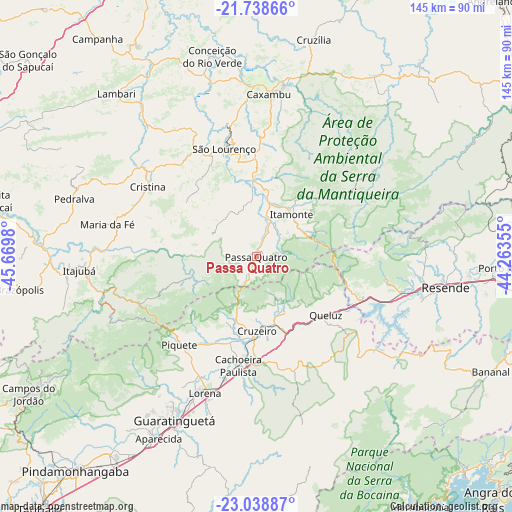
Passa Quatro GPS coordinates[2]
22° 23' 25.008" South, 44° 58' 0.012" West
| Map corner | latitude | longitude |
|---|---|---|
| Upper-left | -21.73866°, | -45.6698° |
| Center: | -22.39028°, | -44.96667° |
| Lower-right: | -23.03887°, | -44.26355° |
| Map W x H: | 144.6×144.6 km | = 89.9×89.9mi |
| max Lat: | 2.81972° ⇑72.4% North |
| Passa Quatro: | -22.39028° |
| min Lat: | ⇓27.6% South -33.69111° |
| min Long | Passa Quatro | max Long |
| -72.89583° | -44.96667° | -32.41083° |
| W 51.4%⇐ | ⇒48.6% E |
Elevation
Elevation of Passa Quatro is 924 m = 3031 ft, and this is 543.1 m = 1782 ft above average elevation for this country.
| Max E: |
1603 m = 5259 ft | 3.7% |
| Passa Quatro | 924 m 3031 ft | |
| Avg. | 380.9 m = 1250 ft | |
Min E: |
0 m = 0 ft | 96.3% |
See also: Brazil elevation on elevation.city.
Geographical zone
Passa Quatro is located in South Torrid zone (between Equator and Tropic of Capricorn). Distance of this Southern Tropic circle is 116.4 km =72.3 mi to South.| Distance of | km | miles | from Passa Quatro |
|---|---|---|---|
| Equator | 2489.6 | 1547 | to North |
| Tropic Capricorn | 116.4 | 72.3 | to South |
| Antarctic Circle | 4911.6 | 3051.9 | to South |
| South Pole | 7517.5 | 4671.2 | to South |


Nearby cities:
15 places around Passa Quatro: (largest is in red/bold)
• Aparecida
57.5 km =35.7 mi,  208°
208°
• Baependi
48.6 km =30.2 mi,  9°
9°
• Caxambu
46.1 km =28.6 mi,  4°
4°
• Conceição do Rio Verde
57.9 km =36 mi,  347°
347°
• Cruzeiro
20.3 km =12.6 mi,  181°
181°
• Cruzília
63.5 km =39.5 mi, 14°
• Guaratinguetá
52.7 km =32.7 mi, 206°
• Itajubá
50.1 km =31.1 mi,  265°
265°
• Itanhandu
11 km =6.8 mi,  17°
17°
• Itatiaia
43.1 km =26.8 mi,  105°
105°
• Lambari
60.7 km =37.7 mi,  319°
319°
• Lorena
41.2 km =25.6 mi,  203°
203°
• Piquete
32.9 km =20.4 mi,  220°
220°
• Resende
54.2 km =33.7 mi,  99°
99°
• São Lourenço
31.8 km =19.8 mi,  343°
343°
Sources, notices
• [Note1] Compared only with cities in Brazil existing in our database
• [Src1] Map data: © OpenStreetMap contributors (CC-BY-SA)
• [Src2] Other city data from geonames.org with taken over terms of usage.
• [Src3] Geographical zone / Annual Mean Temperature by Robert A. Rohde @ Wikipedia
