Piquete geodata
Piquete (São Paulo) is a populated place; located in Brazil in America/Sao_Paulo (GMT-3) time zone. With population of 13,844 people, there are 1304 cities with bigger population in this country. Compared to other cities in Brazil, 74.9% of cities are located further ↑North; 50.6% of cities are located further ←West and 76.2% of cities have lower elevation than Piquete. Note1


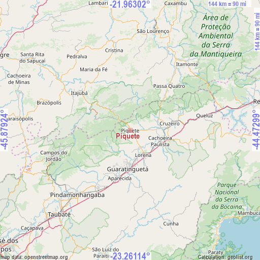
Piquete GPS coordinates[2]
22° 36' 48.996" South, 45° 10' 33.996" West
| Map corner | latitude | longitude |
|---|---|---|
| Upper-left | -21.96302°, | -45.87924° |
| Center: | -22.61361°, | -45.17611° |
| Lower-right: | -23.26114°, | -44.47299° |
| Map W x H: | 144.3×144.3 km | = 89.7×89.7mi |
| max Lat: | 2.81972° ⇑74.9% North |
| Piquete: | -22.61361° |
| min Lat: | ⇓25.1% South -33.69111° |
| min Long | Piquete | max Long |
| -72.89583° | -45.17611° | -32.41083° |
| W 50.6%⇐ | ⇒49.4% E |
Elevation
Elevation of Piquete is 642 m = 2106 ft, and this is 261.1 m = 857 ft above average elevation for this country.
| Max E: |
1603 m = 5259 ft | 23.8% |
| Piquete | 642 m 2106 ft | |
| Avg. | 380.9 m = 1250 ft | |
Min E: |
0 m = 0 ft | 76.2% |
See also: Brazil elevation on elevation.city.
Geographical zone
Piquete is located in South Torrid zone (between Equator and Tropic of Capricorn). Distance of this Southern Tropic circle is 91.5 km =56.9 mi to South.| Distance of | km | miles | from Piquete |
|---|---|---|---|
| Equator | 2514.4 | 1562.4 | to North |
| Tropic Capricorn | 91.5 | 56.9 | to South |
| Antarctic Circle | 4886.8 | 3036.5 | to South |
| South Pole | 7492.7 | 4655.7 | to South |


Nearby cities:
15 places around Piquete: (largest is in red/bold)
• Aparecida
26.5 km =16.5 mi,  191°
191°
• Campos do Jordão
44.8 km =27.8 mi,  251°
251°
• Cruzeiro
21.5 km =13.4 mi,  77°
77°
• Cunha
55.8 km =34.7 mi,  156°
156°
• Guaratinguetá
22.6 km =14 mi,  184°
184°
• Itajubá
35.3 km =21.9 mi,  306°
306°
• Itanhandu
43.2 km =26.8 mi,  35°
35°
• Itatiaia
64.3 km =40 mi, 78°
• Lorena
14.1 km =8.8 mi, 157°
• Paraisópolis
62.3 km =38.7 mi,  276°
276°
• Passa Quatro
32.9 km =20.4 mi, 40°
• Pindamonhangaba
45.2 km =28.1 mi,  220°
220°
• São Lourenço
56.7 km =35.2 mi,  12°
12°
• Taubaté
60.1 km =37.3 mi, 220°
• Tremembé
54.2 km =33.7 mi, 224°
Sources, notices
• [Note1] Compared only with cities in Brazil existing in our database
• [Src1] Map data: © OpenStreetMap contributors (CC-BY-SA)
• [Src2] Other city data from geonames.org with taken over terms of usage.
• [Src3] Geographical zone / Annual Mean Temperature by Robert A. Rohde @ Wikipedia
