Montenegro geodata
Montenegro (Rio Grande do Sul) is a seat of a second-order administrative division; located in Brazil in America/Sao_Paulo (GMT-3) time zone. With population of 54,057 people, there are 406 cities with bigger population in this country. Compared to other cities in Brazil, 97.6% of cities are located further ↑North; 85.3% of cities are located further →East and 88.3% of cities have higher elevation than Montenegro. Note1


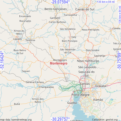
Montenegro GPS coordinates[2]
29° 41' 18.996" South, 51° 27' 39.996" West
| Map corner | latitude | longitude |
|---|---|---|
| Upper-left | -29.07594°, | -52.16424° |
| Center: | -29.68861°, | -51.46111° |
| Lower-right: | -30.29757°, | -50.75799° |
| Map W x H: | 135.8×135.8 km | = 84.4×84.4mi |
| max Lat: | 2.81972° ⇑97.6% North |
| Montenegro: | -29.68861° |
| min Lat: | ⇓2.4% South -33.69111° |
| min Long | Montenegro | max Long |
| -72.89583° | -51.46111° | -32.41083° |
| W 14.7%⇐ | ⇒85.3% E |
Elevation
Elevation of Montenegro is 21 m = 69 ft, and this is 359.9 m = 1181 ft below average elevation for this country.
| Max E: |
1603 m = 5259 ft | 88.3% |
| Avg. | 380.9 m = 1250 ft | |
| Montenegro | 21 m = 69 ft | |
Min E: |
0 m = 0 ft | 11.7% |
See also: Montenegro elevation on elevation.city.
Geographical zone
Montenegro is located in South temperate zone (between Tropic of Capricorn and the Antarctic Circle). Distance of this Southern Tropic circle is 695.1 km =431.9 mi to North.| Distance of | km | miles | from Montenegro |
|---|---|---|---|
| Equator | 3301.1 | 2051.2 | to North |
| Tropic Capricorn | 695.1 | 431.9 | to North |
| Antarctic Circle | 4100.1 | 2547.7 | to South |
| South Pole | 6706 | 4166.9 | to South |


Nearby cities:
15 places around Montenegro: (largest is in red/bold)
• Canoas
37 km =23 mi,  133°
133°
• Carlos Barbosa
43.7 km =27.2 mi,  354°
354°
• Charqueadas
33.6 km =20.9 mi,  208°
208°
• Esteio
33.3 km =20.7 mi, 125°
• Estância Velha
28.1 km =17.5 mi,  80°
80°
• Ivoti
31 km =19.3 mi,  69°
69°
• Novo Hamburgo
32 km =19.9 mi,  87°
87°
• Portão
21.2 km =13.2 mi, 93°
• Sapucaia
34.1 km =21.2 mi,  118°
118°
• São Jerônimo
39.2 km =24.4 mi,  219°
219°
• São Leopoldo
31.3 km =19.4 mi,  104°
104°
• São Sebastião do Caí
14 km =8.7 mi,  36°
36°
• Taquari
40.9 km =25.4 mi,  252°
252°
• Teutônia
42.8 km =26.6 mi,  308°
308°
• Triunfo
37.6 km =23.4 mi, 221°
Sources, notices
• [Note1] Compared only with cities in Brazil existing in our database
• [Src1] Map data: © OpenStreetMap contributors (CC-BY-SA)
• [Src2] Other city data from geonames.org with taken over terms of usage.
• [Src3] Geographical zone / Annual Mean Temperature by Robert A. Rohde @ Wikipedia
